You are here: Home > Network List > TJ - Tajikistan National Seismic Network Stations List
> Station GARM Garm, Tajikistan > Earthquake Result Viewer
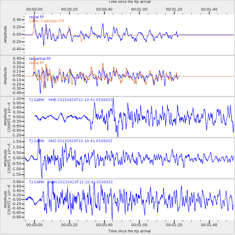
GARM Garm, Tajikistan - Earthquake Result Viewer
*The percent match for this event was below the threshold and hence no stack was calculated.
| Earthquake location: |
Near East Coast Of Honshu, Japan |
| Earthquake latitude/longitude: |
35.7/141.0 |
| Earthquake time(UTC): |
2013/04/29 (119) 13:01:44 GMT |
| Earthquake Depth: |
35 km |
| Earthquake Magnitude: |
5.6 MW, 5.5 MW |
| Earthquake Catalog/Contributor: |
NEIC PDE/NEIC PDE-W |
|
| Network: |
TJ Tajikistan National Seismic Network |
| Station: |
GARM Garm, Tajikistan |
| Lat/Lon: |
39.00 N/70.32 E |
| Elevation: |
1305 m |
|
| Distance: |
55.0 deg |
| Az: |
296.102 deg |
| Baz: |
69.72 deg |
| Ray Param: |
$rayparam |
*The percent match for this event was below the threshold and hence was not used in the summary stack. |
|
| Radial Match: |
72.0208 % |
| Radial Bump: |
400 |
| Transverse Match: |
66.52654 % |
| Transverse Bump: |
400 |
| SOD ConfigId: |
512894 |
| Insert Time: |
2013-09-13 20:24:02.082 +0000 |
| GWidth: |
2.5 |
| Max Bumps: |
400 |
| Tol: |
0.001 |
|
Signal To Noise
| Channel | StoN | STA | LTA |
| TJ:GARM: :HHZ:20130429T13:10:41.639993Z | 6.422111 | 7.74492E-7 | 1.2059772E-7 |
| TJ:GARM: :HHN:20130429T13:10:41.639993Z | 1.1713141 | 1.1257847E-7 | 9.6112956E-8 |
| TJ:GARM: :HHE:20130429T13:10:41.639993Z | 3.8408322 | 4.1812552E-7 | 1.0886326E-7 |
| Arrivals |
| Ps | |
| PpPs | |
| PsPs/PpSs | |


