You are here: Home > Network List > CB - China National Seismic Network Stations List
> Station LZH Lanzhou,Gansu Province > Earthquake Result Viewer
LZH Lanzhou,Gansu Province - Earthquake Result Viewer
| Earthquake location: |
Bismarck Sea |
| Earthquake latitude/longitude: |
-3.5/146.7 |
| Earthquake time(UTC): |
2014/07/29 (210) 13:27:40 GMT |
| Earthquake Depth: |
6.9 km |
| Earthquake Magnitude: |
5.8 MB |
| Earthquake Catalog/Contributor: |
NEIC PDE/NEIC COMCAT |
|
| Network: |
CB China National Seismic Network |
| Station: |
LZH Lanzhou,Gansu Province |
| Lat/Lon: |
36.09 N/103.84 E |
| Elevation: |
1560 m |
|
| Distance: |
56.1 deg |
| Az: |
318.437 deg |
| Baz: |
125.156 deg |
| Ray Param: |
0.06436654 |
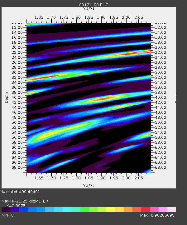
| Estimated Moho Depth: |
21.25 km |
| Estimated Crust Vp/Vs: |
2.10 |
| Assumed Crust Vp: |
6.306 km/s |
| Estimated Crust Vs: |
3.006 km/s |
| Estimated Crust Poisson's Ratio: |
0.35 |
|
| Radial Match: |
90.40691 % |
| Radial Bump: |
330 |
| Transverse Match: |
82.29846 % |
| Transverse Bump: |
400 |
| SOD ConfigId: |
3390531 |
| Insert Time: |
2019-04-13 02:13:02.702 +0000 |
| GWidth: |
2.5 |
| Max Bumps: |
400 |
| Tol: |
0.001 |
|

Signal To Noise
| Channel | StoN | STA | LTA |
| CB:LZH:00:BHZ:20140729T13:36:48.599988Z | 3.3293896 | 3.8081652E-7 | 1.14380285E-7 |
| CB:LZH:00:BHN:20140729T13:36:48.599988Z | 1.335315 | 2.0534468E-7 | 1.5377995E-7 |
| CB:LZH:00:BHE:20140729T13:36:48.599988Z | 1.3316141 | 1.7567967E-7 | 1.3192987E-7 |
| Arrivals |
| Ps | 3.9 SECOND |
| PpPs | 10 SECOND |
| PsPs/PpSs | 14 SECOND |


