You are here: Home > Network List > PS - Pacific21 Stations List
> Station PSI Parapat, Indonesia > Earthquake Result Viewer
PSI Parapat, Indonesia - Earthquake Result Viewer
| Earthquake location: |
Southeast Of Loyalty Islands |
| Earthquake latitude/longitude: |
-22.3/170.9 |
| Earthquake time(UTC): |
1998/01/04 (004) 06:11:58 GMT |
| Earthquake Depth: |
101 km |
| Earthquake Magnitude: |
6.4 MB, 7.4 UNKNOWN, 7.3 ME |
| Earthquake Catalog/Contributor: |
WHDF/NEIC |
|
| Network: |
PS Pacific21 |
| Station: |
PSI Parapat, Indonesia |
| Lat/Lon: |
2.69 N/98.92 E |
| Elevation: |
987 m |
|
| Distance: |
74.4 deg |
| Az: |
279.547 deg |
| Baz: |
113.899 deg |
| Ray Param: |
0.052099336 |
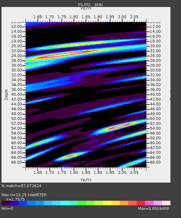
| Estimated Moho Depth: |
23.25 km |
| Estimated Crust Vp/Vs: |
1.76 |
| Assumed Crust Vp: |
6.468 km/s |
| Estimated Crust Vs: |
3.68 km/s |
| Estimated Crust Poisson's Ratio: |
0.26 |
|
| Radial Match: |
97.072624 % |
| Radial Bump: |
400 |
| Transverse Match: |
97.82231 % |
| Transverse Bump: |
400 |
| SOD ConfigId: |
4480 |
| Insert Time: |
2010-02-27 03:22:39.031 +0000 |
| GWidth: |
2.5 |
| Max Bumps: |
400 |
| Tol: |
0.001 |
|
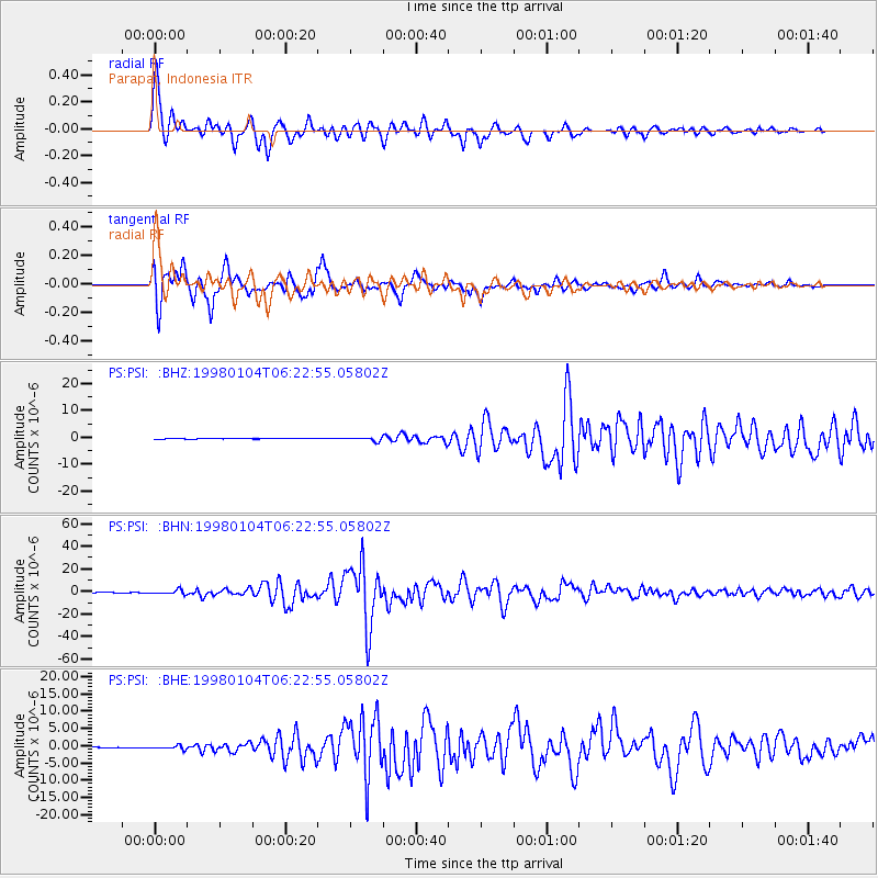
Signal To Noise
| Channel | StoN | STA | LTA |
| PS:PSI: :BHN:19980104T06:22:55.05802Z | 21.466084 | 1.7769261E-6 | 8.27783E-8 |
| PS:PSI: :BHE:19980104T06:22:55.05802Z | 6.8067365 | 4.967286E-7 | 7.2976036E-8 |
| PS:PSI: :BHZ:19980104T06:22:55.05802Z | 10.091503 | 6.8544136E-7 | 6.792263E-8 |
| Arrivals |
| Ps | 2.8 SECOND |
| PpPs | 9.6 SECOND |
| PsPs/PpSs | 12 SECOND |


