You are here: Home > Network List > PS - Pacific21 Stations List
> Station PSI Parapat, Indonesia > Earthquake Result Viewer
PSI Parapat, Indonesia - Earthquake Result Viewer
| Earthquake location: |
Irian Jaya, Indonesia |
| Earthquake latitude/longitude: |
-3.2/140.6 |
| Earthquake time(UTC): |
1998/03/26 (085) 23:36:11 GMT |
| Earthquake Depth: |
10 km |
| Earthquake Magnitude: |
5.6 MB, 5.6 MS, 5.7 UNKNOWN, 5.5 MW |
| Earthquake Catalog/Contributor: |
WHDF/NEIC |
|
| Network: |
PS Pacific21 |
| Station: |
PSI Parapat, Indonesia |
| Lat/Lon: |
2.69 N/98.92 E |
| Elevation: |
987 m |
|
| Distance: |
42.1 deg |
| Az: |
277.59 deg |
| Baz: |
97.798 deg |
| Ray Param: |
0.07338413 |
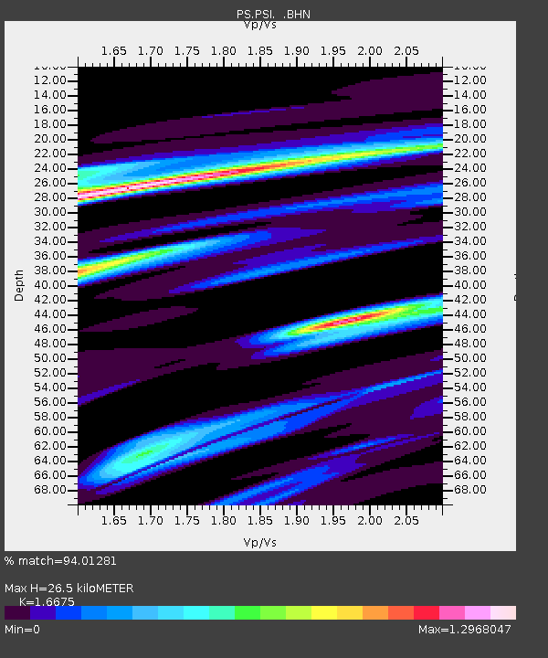
| Estimated Moho Depth: |
26.5 km |
| Estimated Crust Vp/Vs: |
1.67 |
| Assumed Crust Vp: |
6.468 km/s |
| Estimated Crust Vs: |
3.879 km/s |
| Estimated Crust Poisson's Ratio: |
0.22 |
|
| Radial Match: |
94.01281 % |
| Radial Bump: |
398 |
| Transverse Match: |
90.34398 % |
| Transverse Bump: |
400 |
| SOD ConfigId: |
4480 |
| Insert Time: |
2010-02-27 03:22:53.859 +0000 |
| GWidth: |
2.5 |
| Max Bumps: |
400 |
| Tol: |
0.001 |
|
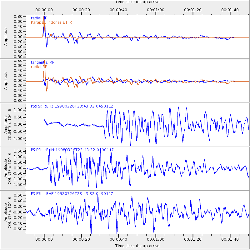
Signal To Noise
| Channel | StoN | STA | LTA |
| PS:PSI: :BHN:19980326T23:43:32.049011Z | 9.889222 | 6.5129177E-7 | 6.585875E-8 |
| PS:PSI: :BHE:19980326T23:43:32.049011Z | 2.1845367 | 1.3385234E-7 | 6.1272644E-8 |
| PS:PSI: :BHZ:19980326T23:43:32.049011Z | 4.6829896 | 4.5265878E-7 | 9.6660216E-8 |
| Arrivals |
| Ps | 2.9 SECOND |
| PpPs | 10 SECOND |
| PsPs/PpSs | 13 SECOND |


