You are here: Home > Network List > LD - Lamont-Doherty Cooperative Seismographic Network Stations List
> Station BRNJ Basking Ridge, New Jersey > Earthquake Result Viewer
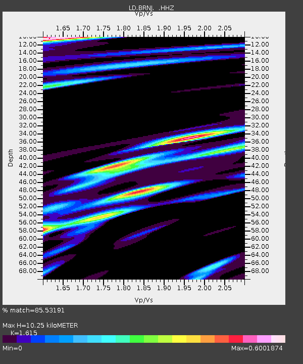
BRNJ Basking Ridge, New Jersey - Earthquake Result Viewer
| Earthquake location: |
Azores Islands Region |
| Earthquake latitude/longitude: |
37.6/-24.9 |
| Earthquake time(UTC): |
2013/04/30 (120) 06:25:23 GMT |
| Earthquake Depth: |
10 km |
| Earthquake Magnitude: |
5.8 MW, 5.9 MW, 5.9 MB |
| Earthquake Catalog/Contributor: |
NEIC PDE/NEIC PDE-W |
|
| Network: |
LD Lamont-Doherty Cooperative Seismographic Network |
| Station: |
BRNJ Basking Ridge, New Jersey |
| Lat/Lon: |
40.68 N/74.57 W |
| Elevation: |
50 m |
|
| Distance: |
38.2 deg |
| Az: |
290.502 deg |
| Baz: |
78.06 deg |
| Ray Param: |
0.075683184 |
| Estimated Moho Depth: |
10.25 km |
| Estimated Crust Vp/Vs: |
1.62 |
| Assumed Crust Vp: |
6.283 km/s |
| Estimated Crust Vs: |
3.891 km/s |
| Estimated Crust Poisson's Ratio: |
0.19 |
|
| Radial Match: |
85.53191 % |
| Radial Bump: |
400 |
| Transverse Match: |
73.93469 % |
| Transverse Bump: |
354 |
| SOD ConfigId: |
512894 |
| Insert Time: |
2013-09-13 20:45:37.970 +0000 |
| GWidth: |
2.5 |
| Max Bumps: |
400 |
| Tol: |
0.001 |
|

Signal To Noise
| Channel | StoN | STA | LTA |
| LD:BRNJ: :HHZ:20130430T06:32:12.316006Z | 8.838631 | 1.4178358E-6 | 1.6041352E-7 |
| LD:BRNJ: :HHN:20130430T06:32:12.316006Z | 3.39128 | 3.9182999E-7 | 1.15540445E-7 |
| LD:BRNJ: :HHE:20130430T06:32:12.316006Z | 7.064517 | 7.135376E-7 | 1.0100303E-7 |
| Arrivals |
| Ps | 1.1 SECOND |
| PpPs | 4.0 SECOND |
| PsPs/PpSs | 5.0 SECOND |


