You are here: Home > Network List > PE - Penn State Network Stations List
> Station WRPS We R Penn State > Earthquake Result Viewer
WRPS We R Penn State - Earthquake Result Viewer

| Earthquake location: |
Azores Islands Region |
| Earthquake latitude/longitude: |
37.6/-24.9 |
| Earthquake time(UTC): |
2013/04/30 (120) 06:25:23 GMT |
| Earthquake Depth: |
10 km |
| Earthquake Magnitude: |
5.8 MW, 5.9 MW, 5.9 MB |
| Earthquake Catalog/Contributor: |
NEIC PDE/NEIC PDE-W |
|
| Network: |
PE Penn State Network |
| Station: |
WRPS We R Penn State |
| Lat/Lon: |
40.79 N/77.87 W |
| Elevation: |
320 m |
|
| Distance: |
40.7 deg |
| Az: |
291.535 deg |
| Baz: |
76.712 deg |
| Ray Param: |
0.07427727 |
| Estimated Moho Depth: |
17.0 km |
| Estimated Crust Vp/Vs: |
1.71 |
| Assumed Crust Vp: |
6.121 km/s |
| Estimated Crust Vs: |
3.579 km/s |
| Estimated Crust Poisson's Ratio: |
0.24 |
|
| Radial Match: |
83.93564 % |
| Radial Bump: |
228 |
| Transverse Match: |
66.88051 % |
| Transverse Bump: |
378 |
| SOD ConfigId: |
512894 |
| Insert Time: |
2013-09-13 20:51:48.516 +0000 |
| GWidth: |
2.5 |
| Max Bumps: |
400 |
| Tol: |
0.001 |
|
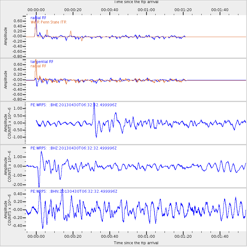
Signal To Noise
| Channel | StoN | STA | LTA |
| PE:WRPS: :BHZ:20130430T06:32:32.499996Z | 10.624939 | 9.714611E-7 | 9.1432156E-8 |
| PE:WRPS: :BHN:20130430T06:32:32.499996Z | 3.007932 | 2.3457875E-7 | 7.798672E-8 |
| PE:WRPS: :BHE:20130430T06:32:32.499996Z | 5.8890133 | 5.6653914E-7 | 9.6202726E-8 |
| Arrivals |
| Ps | 2.1 SECOND |
| PpPs | 7.1 SECOND |
| PsPs/PpSs | 9.2 SECOND |


