You are here: Home > Network List > PO - Portable Observatories for Lithospheric Analysis and Research Investigating Seis Stations List
> Station BMRO Maryville Lake, ON, CANADA.A > Earthquake Result Viewer
BMRO Maryville Lake, ON, CANADA.A - Earthquake Result Viewer
| Earthquake location: |
Azores Islands Region |
| Earthquake latitude/longitude: |
37.6/-24.9 |
| Earthquake time(UTC): |
2013/04/30 (120) 06:25:23 GMT |
| Earthquake Depth: |
10 km |
| Earthquake Magnitude: |
5.8 MW, 5.9 MW, 5.9 MB |
| Earthquake Catalog/Contributor: |
NEIC PDE/NEIC PDE-W |
|
| Network: |
PO Portable Observatories for Lithospheric Analysis and Research Investigating Seis |
| Station: |
BMRO Maryville Lake, ON, CANADA.A |
| Lat/Lon: |
44.60 N/81.22 W |
| Elevation: |
217 m |
|
| Distance: |
42.3 deg |
| Az: |
297.923 deg |
| Baz: |
79.236 deg |
| Ray Param: |
0.07326645 |
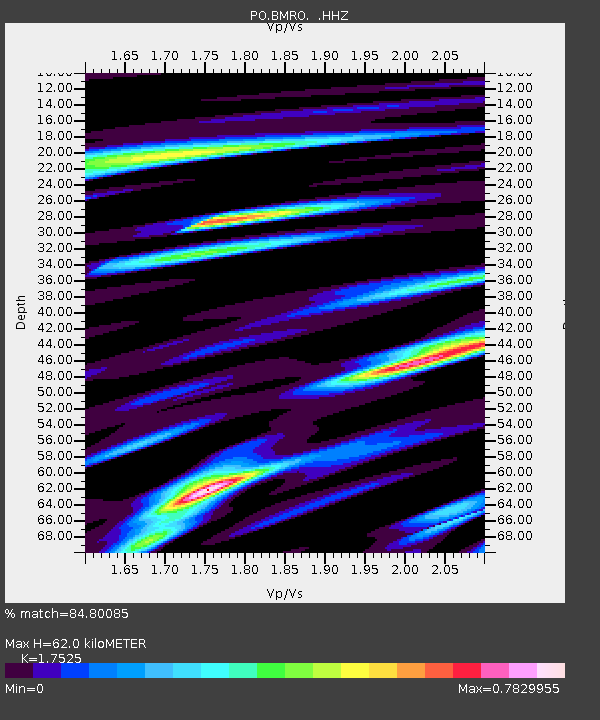
| Estimated Moho Depth: |
62.0 km |
| Estimated Crust Vp/Vs: |
1.75 |
| Assumed Crust Vp: |
6.53 km/s |
| Estimated Crust Vs: |
3.726 km/s |
| Estimated Crust Poisson's Ratio: |
0.26 |
|
| Radial Match: |
84.80085 % |
| Radial Bump: |
358 |
| Transverse Match: |
63.478374 % |
| Transverse Bump: |
400 |
| SOD ConfigId: |
512894 |
| Insert Time: |
2013-09-13 20:52:20.473 +0000 |
| GWidth: |
2.5 |
| Max Bumps: |
400 |
| Tol: |
0.001 |
|

Signal To Noise
| Channel | StoN | STA | LTA |
| PO:BMRO: :HHZ:20130430T06:32:45.830013Z | 11.555092 | 1.1721501E-6 | 1.0144013E-7 |
| PO:BMRO: :HHN:20130430T06:32:45.830013Z | 1.9103228 | 1.7359612E-7 | 9.087267E-8 |
| PO:BMRO: :HHE:20130430T06:32:45.830013Z | 7.6562924 | 6.9136513E-7 | 9.0300254E-8 |
| Arrivals |
| Ps | 7.7 SECOND |
| PpPs | 24 SECOND |
| PsPs/PpSs | 32 SECOND |


