You are here: Home > Network List > PO - Portable Observatories for Lithospheric Analysis and Research Investigating Seis Stations List
> Station KLBO KILLBEAR, ON > Earthquake Result Viewer
KLBO KILLBEAR, ON - Earthquake Result Viewer
| Earthquake location: |
Azores Islands Region |
| Earthquake latitude/longitude: |
37.6/-24.9 |
| Earthquake time(UTC): |
2013/04/30 (120) 06:25:23 GMT |
| Earthquake Depth: |
10 km |
| Earthquake Magnitude: |
5.8 MW, 5.9 MW, 5.9 MB |
| Earthquake Catalog/Contributor: |
NEIC PDE/NEIC PDE-W |
|
| Network: |
PO Portable Observatories for Lithospheric Analysis and Research Investigating Seis |
| Station: |
KLBO KILLBEAR, ON |
| Lat/Lon: |
45.36 N/80.21 W |
| Elevation: |
177 m |
|
| Distance: |
41.4 deg |
| Az: |
298.86 deg |
| Baz: |
80.641 deg |
| Ray Param: |
0.07378854 |
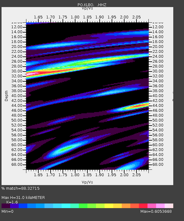
| Estimated Moho Depth: |
31.0 km |
| Estimated Crust Vp/Vs: |
1.60 |
| Assumed Crust Vp: |
6.53 km/s |
| Estimated Crust Vs: |
4.082 km/s |
| Estimated Crust Poisson's Ratio: |
0.18 |
|
| Radial Match: |
88.32715 % |
| Radial Bump: |
311 |
| Transverse Match: |
60.967613 % |
| Transverse Bump: |
400 |
| SOD ConfigId: |
512894 |
| Insert Time: |
2013-09-13 20:52:55.917 +0000 |
| GWidth: |
2.5 |
| Max Bumps: |
400 |
| Tol: |
0.001 |
|

Signal To Noise
| Channel | StoN | STA | LTA |
| PO:KLBO: :HHZ:20130430T06:32:39.019985Z | 13.096312 | 3.9899018E-7 | 3.0465845E-8 |
| PO:KLBO: :HHN:20130430T06:32:39.019985Z | 1.7942759 | 4.3310934E-8 | 2.413839E-8 |
| PO:KLBO: :HHE:20130430T06:32:39.019985Z | 5.9681673 | 2.3833056E-7 | 3.9933628E-8 |
| Arrivals |
| Ps | 3.1 SECOND |
| PpPs | 11 SECOND |
| PsPs/PpSs | 14 SECOND |


