You are here: Home > Network List > PO - Portable Observatories for Lithospheric Analysis and Research Investigating Seis Stations List
> Station PLIO PELEE ISLAND, ON > Earthquake Result Viewer
PLIO PELEE ISLAND, ON - Earthquake Result Viewer
| Earthquake location: |
Azores Islands Region |
| Earthquake latitude/longitude: |
37.6/-24.9 |
| Earthquake time(UTC): |
2013/04/30 (120) 06:25:23 GMT |
| Earthquake Depth: |
10 km |
| Earthquake Magnitude: |
5.8 MW, 5.9 MW, 5.9 MB |
| Earthquake Catalog/Contributor: |
NEIC PDE/NEIC PDE-W |
|
| Network: |
PO Portable Observatories for Lithospheric Analysis and Research Investigating Seis |
| Station: |
PLIO PELEE ISLAND, ON |
| Lat/Lon: |
41.75 N/82.63 W |
| Elevation: |
143 m |
|
| Distance: |
43.9 deg |
| Az: |
294.192 deg |
| Baz: |
75.548 deg |
| Ray Param: |
0.072246715 |
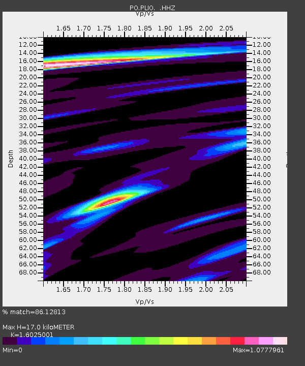
| Estimated Moho Depth: |
17.0 km |
| Estimated Crust Vp/Vs: |
1.60 |
| Assumed Crust Vp: |
6.498 km/s |
| Estimated Crust Vs: |
4.055 km/s |
| Estimated Crust Poisson's Ratio: |
0.18 |
|
| Radial Match: |
86.12813 % |
| Radial Bump: |
309 |
| Transverse Match: |
63.14673 % |
| Transverse Bump: |
400 |
| SOD ConfigId: |
512894 |
| Insert Time: |
2013-09-13 20:53:33.648 +0000 |
| GWidth: |
2.5 |
| Max Bumps: |
400 |
| Tol: |
0.001 |
|

Signal To Noise
| Channel | StoN | STA | LTA |
| PO:PLIO: :HHZ:20130430T06:32:58.989987Z | 9.942497 | 5.0398177E-7 | 5.0689653E-8 |
| PO:PLIO: :HHN:20130430T06:32:58.989987Z | 1.6090568 | 6.9187756E-8 | 4.2998952E-8 |
| PO:PLIO: :HHE:20130430T06:32:58.989987Z | 8.693937 | 3.1799905E-7 | 3.6577102E-8 |
| Arrivals |
| Ps | 1.7 SECOND |
| PpPs | 6.3 SECOND |
| PsPs/PpSs | 8.0 SECOND |


