You are here: Home > Network List > TA - USArray Transportable Network (new EarthScope stations) Stations List
> Station 150A Eclectic, AL, USA > Earthquake Result Viewer
150A Eclectic, AL, USA - Earthquake Result Viewer
| Earthquake location: |
Azores Islands Region |
| Earthquake latitude/longitude: |
37.6/-24.9 |
| Earthquake time(UTC): |
2013/04/30 (120) 06:25:23 GMT |
| Earthquake Depth: |
10 km |
| Earthquake Magnitude: |
5.8 MW, 5.9 MW, 5.9 MB |
| Earthquake Catalog/Contributor: |
NEIC PDE/NEIC PDE-W |
|
| Network: |
TA USArray Transportable Network (new EarthScope stations) |
| Station: |
150A Eclectic, AL, USA |
| Lat/Lon: |
32.61 N/86.02 W |
| Elevation: |
145 m |
|
| Distance: |
49.5 deg |
| Az: |
283.565 deg |
| Baz: |
66.19 deg |
| Ray Param: |
0.06867341 |
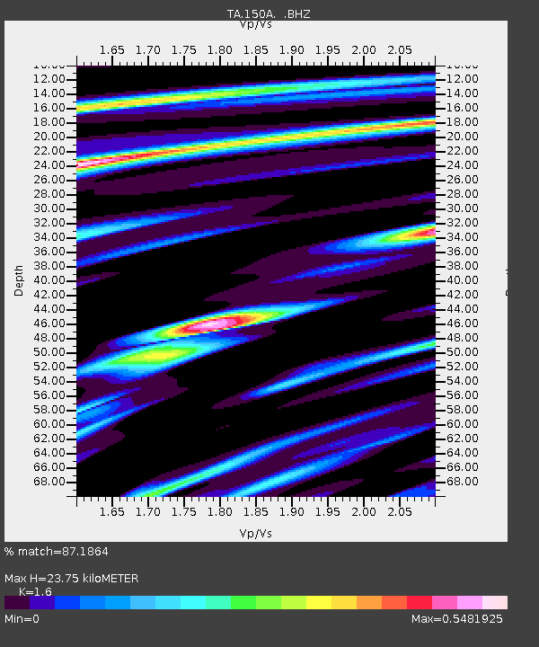
| Estimated Moho Depth: |
23.75 km |
| Estimated Crust Vp/Vs: |
1.60 |
| Assumed Crust Vp: |
6.565 km/s |
| Estimated Crust Vs: |
4.103 km/s |
| Estimated Crust Poisson's Ratio: |
0.18 |
|
| Radial Match: |
87.1864 % |
| Radial Bump: |
356 |
| Transverse Match: |
70.03909 % |
| Transverse Bump: |
400 |
| SOD ConfigId: |
512894 |
| Insert Time: |
2013-09-13 20:55:49.020 +0000 |
| GWidth: |
2.5 |
| Max Bumps: |
400 |
| Tol: |
0.001 |
|
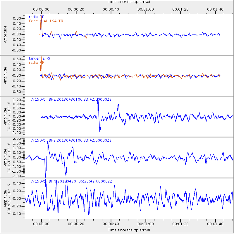
Signal To Noise
| Channel | StoN | STA | LTA |
| TA:150A: :BHZ:20130430T06:33:42.600002Z | 7.6110334 | 8.9072466E-7 | 1.17030716E-7 |
| TA:150A: :BHN:20130430T06:33:42.600002Z | 2.5592608 | 2.22616E-7 | 8.6984485E-8 |
| TA:150A: :BHE:20130430T06:33:42.600002Z | 10.268649 | 5.6589937E-7 | 5.5109428E-8 |
| Arrivals |
| Ps | 2.3 SECOND |
| PpPs | 8.8 SECOND |
| PsPs/PpSs | 11 SECOND |


