You are here: Home > Network List > US - United States National Seismic Network Stations List
> Station MIAR Mount Ida, Arkansas, USA > Earthquake Result Viewer
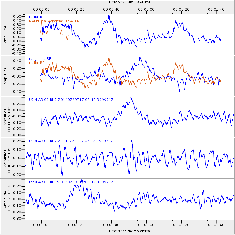
MIAR Mount Ida, Arkansas, USA - Earthquake Result Viewer
*The percent match for this event was below the threshold and hence no stack was calculated.
| Earthquake location: |
South Of Fiji Islands |
| Earthquake latitude/longitude: |
-23.6/-176.5 |
| Earthquake time(UTC): |
2014/07/29 (210) 16:50:13 GMT |
| Earthquake Depth: |
35 km |
| Earthquake Magnitude: |
5.2 MW, 5.2 mb |
| Earthquake Catalog/Contributor: |
ISC/ISC |
|
| Network: |
US United States National Seismic Network |
| Station: |
MIAR Mount Ida, Arkansas, USA |
| Lat/Lon: |
34.55 N/93.58 W |
| Elevation: |
207 m |
|
| Distance: |
97.5 deg |
| Az: |
55.718 deg |
| Baz: |
246.715 deg |
| Ray Param: |
$rayparam |
*The percent match for this event was below the threshold and hence was not used in the summary stack. |
|
| Radial Match: |
28.95164 % |
| Radial Bump: |
400 |
| Transverse Match: |
38.9334 % |
| Transverse Bump: |
400 |
| SOD ConfigId: |
3390531 |
| Insert Time: |
2019-04-13 02:20:38.801 +0000 |
| GWidth: |
2.5 |
| Max Bumps: |
400 |
| Tol: |
0.001 |
|
Signal To Noise
| Channel | StoN | STA | LTA |
| US:MIAR:00:BHZ:20140729T17:03:12.399971Z | 0.49770817 | 3.9111114E-8 | 7.8582424E-8 |
| US:MIAR:00:BH1:20140729T17:03:12.399971Z | 1.8851516 | 9.448201E-8 | 5.011905E-8 |
| US:MIAR:00:BH2:20140729T17:03:12.399971Z | 0.60309637 | 2.8729456E-8 | 4.7636597E-8 |
| Arrivals |
| Ps | |
| PpPs | |
| PsPs/PpSs | |


