You are here: Home > Network List > TA - USArray Transportable Network (new EarthScope stations) Stations List
> Station 152A Waverly Hall, GA, USA > Earthquake Result Viewer
152A Waverly Hall, GA, USA - Earthquake Result Viewer
| Earthquake location: |
Azores Islands Region |
| Earthquake latitude/longitude: |
37.6/-24.9 |
| Earthquake time(UTC): |
2013/04/30 (120) 06:25:23 GMT |
| Earthquake Depth: |
10 km |
| Earthquake Magnitude: |
5.8 MW, 5.9 MW, 5.9 MB |
| Earthquake Catalog/Contributor: |
NEIC PDE/NEIC PDE-W |
|
| Network: |
TA USArray Transportable Network (new EarthScope stations) |
| Station: |
152A Waverly Hall, GA, USA |
| Lat/Lon: |
32.67 N/84.72 W |
| Elevation: |
214 m |
|
| Distance: |
48.4 deg |
| Az: |
283.055 deg |
| Baz: |
66.555 deg |
| Ray Param: |
0.06935543 |
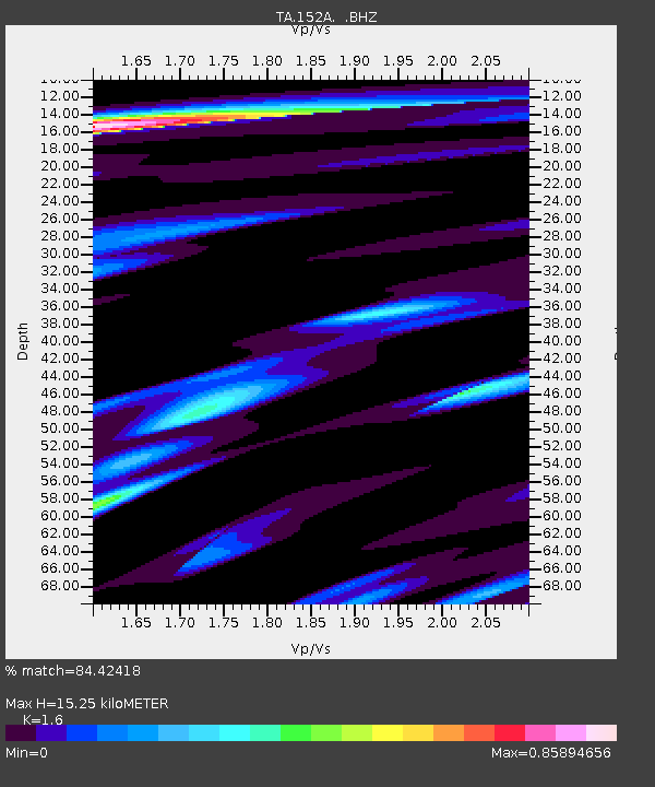
| Estimated Moho Depth: |
15.25 km |
| Estimated Crust Vp/Vs: |
1.60 |
| Assumed Crust Vp: |
6.719 km/s |
| Estimated Crust Vs: |
4.2 km/s |
| Estimated Crust Poisson's Ratio: |
0.18 |
|
| Radial Match: |
84.42418 % |
| Radial Bump: |
349 |
| Transverse Match: |
65.96375 % |
| Transverse Bump: |
400 |
| SOD ConfigId: |
512894 |
| Insert Time: |
2013-09-13 20:55:55.277 +0000 |
| GWidth: |
2.5 |
| Max Bumps: |
400 |
| Tol: |
0.001 |
|

Signal To Noise
| Channel | StoN | STA | LTA |
| TA:152A: :BHZ:20130430T06:33:34.675015Z | 6.4729767 | 8.8430227E-7 | 1.3661447E-7 |
| TA:152A: :BHN:20130430T06:33:34.675015Z | 3.2423286 | 2.5478136E-7 | 7.857974E-8 |
| TA:152A: :BHE:20130430T06:33:34.675015Z | 4.342938 | 4.4152245E-7 | 1.01664455E-7 |
| Arrivals |
| Ps | 1.5 SECOND |
| PpPs | 5.5 SECOND |
| PsPs/PpSs | 6.9 SECOND |


