You are here: Home > Network List > TA - USArray Transportable Network (new EarthScope stations) Stations List
> Station 251A Midway, AL, USA > Earthquake Result Viewer
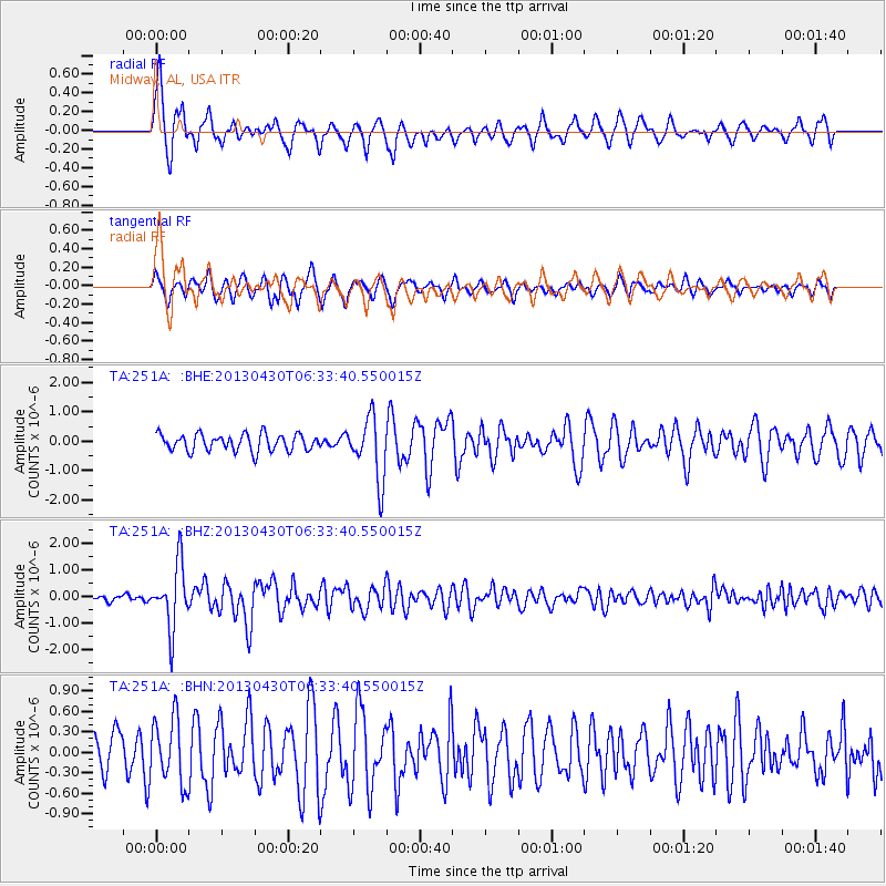
251A Midway, AL, USA - Earthquake Result Viewer

| Earthquake location: |
Azores Islands Region |
| Earthquake latitude/longitude: |
37.6/-24.9 |
| Earthquake time(UTC): |
2013/04/30 (120) 06:25:23 GMT |
| Earthquake Depth: |
10 km |
| Earthquake Magnitude: |
5.8 MW, 5.9 MW, 5.9 MB |
| Earthquake Catalog/Contributor: |
NEIC PDE/NEIC PDE-W |
|
| Network: |
TA USArray Transportable Network (new EarthScope stations) |
| Station: |
251A Midway, AL, USA |
| Lat/Lon: |
32.09 N/85.41 W |
| Elevation: |
139 m |
|
| Distance: |
49.2 deg |
| Az: |
282.67 deg |
| Baz: |
65.934 deg |
| Ray Param: |
0.06884316 |
| Estimated Moho Depth: |
53.75 km |
| Estimated Crust Vp/Vs: |
1.87 |
| Assumed Crust Vp: |
6.719 km/s |
| Estimated Crust Vs: |
3.603 km/s |
| Estimated Crust Poisson's Ratio: |
0.30 |
|
| Radial Match: |
89.04803 % |
| Radial Bump: |
400 |
| Transverse Match: |
70.82217 % |
| Transverse Bump: |
400 |
| SOD ConfigId: |
512894 |
| Insert Time: |
2013-09-13 20:56:23.072 +0000 |
| GWidth: |
2.5 |
| Max Bumps: |
400 |
| Tol: |
0.001 |
|
Signal To Noise
| Channel | StoN | STA | LTA |
| TA:251A: :BHZ:20130430T06:33:40.550015Z | 9.630987 | 1.1961254E-6 | 1.2419551E-7 |
| TA:251A: :BHN:20130430T06:33:40.550015Z | 1.42347 | 4.7604976E-7 | 3.3442907E-7 |
| TA:251A: :BHE:20130430T06:33:40.550015Z | 3.7488496 | 1.0681376E-6 | 2.849241E-7 |
| Arrivals |
| Ps | 7.4 SECOND |
| PpPs | 22 SECOND |
| PsPs/PpSs | 29 SECOND |


