You are here: Home > Network List > TA - USArray Transportable Network (new EarthScope stations) Stations List
> Station 254A Abbeville, GA, USA > Earthquake Result Viewer
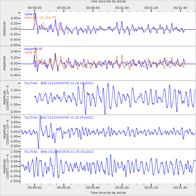
254A Abbeville, GA, USA - Earthquake Result Viewer
*The percent match for this event was below the threshold and hence no stack was calculated.
| Earthquake location: |
Azores Islands Region |
| Earthquake latitude/longitude: |
37.6/-24.9 |
| Earthquake time(UTC): |
2013/04/30 (120) 06:25:23 GMT |
| Earthquake Depth: |
10 km |
| Earthquake Magnitude: |
5.8 MW, 5.9 MW, 5.9 MB |
| Earthquake Catalog/Contributor: |
NEIC PDE/NEIC PDE-W |
|
| Network: |
TA USArray Transportable Network (new EarthScope stations) |
| Station: |
254A Abbeville, GA, USA |
| Lat/Lon: |
31.95 N/83.29 W |
| Elevation: |
78 m |
|
| Distance: |
47.6 deg |
| Az: |
281.516 deg |
| Baz: |
66.286 deg |
| Ray Param: |
$rayparam |
*The percent match for this event was below the threshold and hence was not used in the summary stack. |
|
| Radial Match: |
68.18992 % |
| Radial Bump: |
322 |
| Transverse Match: |
60.009872 % |
| Transverse Bump: |
400 |
| SOD ConfigId: |
512894 |
| Insert Time: |
2013-09-13 20:56:36.642 +0000 |
| GWidth: |
2.5 |
| Max Bumps: |
400 |
| Tol: |
0.001 |
|
Signal To Noise
| Channel | StoN | STA | LTA |
| TA:254A: :BHZ:20130430T06:33:28.350002Z | 4.131668 | 1.5883276E-6 | 3.8442766E-7 |
| TA:254A: :BHN:20130430T06:33:28.350002Z | 2.1659245 | 6.48285E-7 | 2.99311E-7 |
| TA:254A: :BHE:20130430T06:33:28.350002Z | 2.7712953 | 1.0525459E-6 | 3.7980288E-7 |
| Arrivals |
| Ps | |
| PpPs | |
| PsPs/PpSs | |


