You are here: Home > Network List > PS - Pacific21 Stations List
> Station PSI Parapat, Indonesia > Earthquake Result Viewer
PSI Parapat, Indonesia - Earthquake Result Viewer
| Earthquake location: |
Santa Cruz Islands |
| Earthquake latitude/longitude: |
-11.1/166.1 |
| Earthquake time(UTC): |
1995/03/25 (084) 22:44:28 GMT |
| Earthquake Depth: |
77 km |
| Earthquake Magnitude: |
5.9 MB, 5.9 UNKNOWN, 6.3 MW |
| Earthquake Catalog/Contributor: |
WHDF/NEIC |
|
| Network: |
PS Pacific21 |
| Station: |
PSI Parapat, Indonesia |
| Lat/Lon: |
2.69 N/98.92 E |
| Elevation: |
987 m |
|
| Distance: |
68.2 deg |
| Az: |
277.4 deg |
| Baz: |
102.944 deg |
| Ray Param: |
0.056274228 |
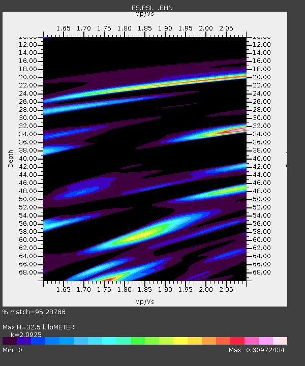
| Estimated Moho Depth: |
32.5 km |
| Estimated Crust Vp/Vs: |
2.09 |
| Assumed Crust Vp: |
6.468 km/s |
| Estimated Crust Vs: |
3.091 km/s |
| Estimated Crust Poisson's Ratio: |
0.35 |
|
| Radial Match: |
95.28766 % |
| Radial Bump: |
400 |
| Transverse Match: |
87.79856 % |
| Transverse Bump: |
400 |
| SOD ConfigId: |
6273 |
| Insert Time: |
2010-02-27 03:23:25.695 +0000 |
| GWidth: |
2.5 |
| Max Bumps: |
400 |
| Tol: |
0.001 |
|
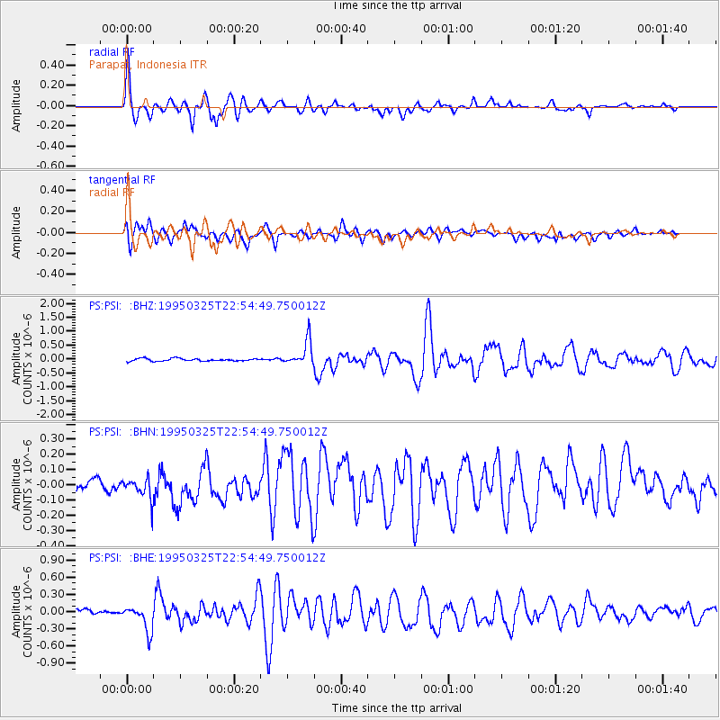
Signal To Noise
| Channel | StoN | STA | LTA |
| PS:PSI: :BHN:19950325T22:54:49.750012Z | 2.2445948 | 7.536974E-8 | 3.3578328E-8 |
| PS:PSI: :BHE:19950325T22:54:49.750012Z | 6.738226 | 2.275025E-7 | 3.3762966E-8 |
| PS:PSI: :BHZ:19950325T22:54:49.750012Z | 9.775412 | 4.472467E-7 | 4.575221E-8 |
| Arrivals |
| Ps | 5.7 SECOND |
| PpPs | 15 SECOND |
| PsPs/PpSs | 21 SECOND |


