You are here: Home > Network List > TA - USArray Transportable Network (new EarthScope stations) Stations List
> Station D49A Beulah Township, ON, CAN > Earthquake Result Viewer
D49A Beulah Township, ON, CAN - Earthquake Result Viewer
| Earthquake location: |
Azores Islands Region |
| Earthquake latitude/longitude: |
37.6/-24.9 |
| Earthquake time(UTC): |
2013/04/30 (120) 06:25:23 GMT |
| Earthquake Depth: |
10 km |
| Earthquake Magnitude: |
5.8 MW, 5.9 MW, 5.9 MB |
| Earthquake Catalog/Contributor: |
NEIC PDE/NEIC PDE-W |
|
| Network: |
TA USArray Transportable Network (new EarthScope stations) |
| Station: |
D49A Beulah Township, ON, CAN |
| Lat/Lon: |
47.27 N/81.36 W |
| Elevation: |
416 m |
|
| Distance: |
41.9 deg |
| Az: |
301.888 deg |
| Baz: |
82.078 deg |
| Ray Param: |
0.07347343 |
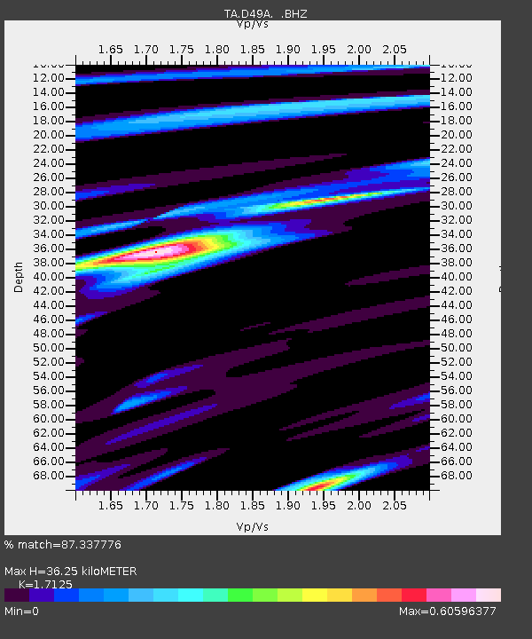
| Estimated Moho Depth: |
36.25 km |
| Estimated Crust Vp/Vs: |
1.71 |
| Assumed Crust Vp: |
6.467 km/s |
| Estimated Crust Vs: |
3.776 km/s |
| Estimated Crust Poisson's Ratio: |
0.24 |
|
| Radial Match: |
87.337776 % |
| Radial Bump: |
339 |
| Transverse Match: |
71.86147 % |
| Transverse Bump: |
400 |
| SOD ConfigId: |
512894 |
| Insert Time: |
2013-09-13 20:59:12.457 +0000 |
| GWidth: |
2.5 |
| Max Bumps: |
400 |
| Tol: |
0.001 |
|

Signal To Noise
| Channel | StoN | STA | LTA |
| TA:D49A: :BHZ:20130430T06:32:43.075009Z | 9.475484 | 9.697474E-7 | 1.0234278E-7 |
| TA:D49A: :BHN:20130430T06:32:43.075009Z | 2.8130932 | 1.9218301E-7 | 6.831733E-8 |
| TA:D49A: :BHE:20130430T06:32:43.075009Z | 6.8217373 | 5.941471E-7 | 8.7096154E-8 |
| Arrivals |
| Ps | 4.3 SECOND |
| PpPs | 14 SECOND |
| PsPs/PpSs | 18 SECOND |


