You are here: Home > Network List > TA - USArray Transportable Network (new EarthScope stations) Stations List
> Station D51A Lot 18 Range III Mazenod Township, QC, CAN > Earthquake Result Viewer
D51A Lot 18 Range III Mazenod Township, QC, CAN - Earthquake Result Viewer
| Earthquake location: |
Azores Islands Region |
| Earthquake latitude/longitude: |
37.6/-24.9 |
| Earthquake time(UTC): |
2013/04/30 (120) 06:25:23 GMT |
| Earthquake Depth: |
10 km |
| Earthquake Magnitude: |
5.8 MW, 5.9 MW, 5.9 MB |
| Earthquake Catalog/Contributor: |
NEIC PDE/NEIC PDE-W |
|
| Network: |
TA USArray Transportable Network (new EarthScope stations) |
| Station: |
D51A Lot 18 Range III Mazenod Township, QC, CAN |
| Lat/Lon: |
47.09 N/79.37 W |
| Elevation: |
282 m |
|
| Distance: |
40.6 deg |
| Az: |
301.35 deg |
| Baz: |
83.124 deg |
| Ray Param: |
0.07429435 |
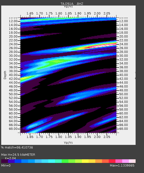
| Estimated Moho Depth: |
24.5 km |
| Estimated Crust Vp/Vs: |
2.04 |
| Assumed Crust Vp: |
6.622 km/s |
| Estimated Crust Vs: |
3.246 km/s |
| Estimated Crust Poisson's Ratio: |
0.34 |
|
| Radial Match: |
86.410736 % |
| Radial Bump: |
302 |
| Transverse Match: |
65.38835 % |
| Transverse Bump: |
400 |
| SOD ConfigId: |
512894 |
| Insert Time: |
2013-09-13 20:59:14.498 +0000 |
| GWidth: |
2.5 |
| Max Bumps: |
400 |
| Tol: |
0.001 |
|

Signal To Noise
| Channel | StoN | STA | LTA |
| TA:D51A: :BHZ:20130430T06:32:32.249996Z | 10.51539 | 8.9606056E-7 | 8.52142E-8 |
| TA:D51A: :BHN:20130430T06:32:32.249996Z | 2.0889506 | 1.4838878E-7 | 7.103508E-8 |
| TA:D51A: :BHE:20130430T06:32:32.249996Z | 6.7515717 | 5.9575973E-7 | 8.824016E-8 |
| Arrivals |
| Ps | 4.1 SECOND |
| PpPs | 11 SECOND |
| PsPs/PpSs | 15 SECOND |


