You are here: Home > Network List > TA - USArray Transportable Network (new EarthScope stations) Stations List
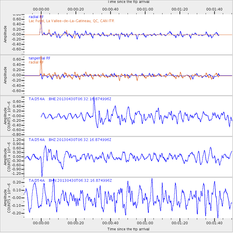
> Station D54A Lac Fusel, La Vallee-de-La-Gatineau, QC, CAN > Earthquake Result Viewer
D54A Lac Fusel, La Vallee-de-La-Gatineau, QC, CAN - Earthquake Result Viewer
| Earthquake location: |
Azores Islands Region |
| Earthquake latitude/longitude: |
37.6/-24.9 |
| Earthquake time(UTC): |
2013/04/30 (120) 06:25:23 GMT |
| Earthquake Depth: |
10 km |
| Earthquake Magnitude: |
5.8 MW, 5.9 MW, 5.9 MB |
| Earthquake Catalog/Contributor: |
NEIC PDE/NEIC PDE-W |
|
| Network: |
TA USArray Transportable Network (new EarthScope stations) |
| Station: |
D54A Lac Fusel, La Vallee-de-La-Gatineau, QC, CAN |
| Lat/Lon: |
47.15 N/76.66 W |
| Elevation: |
415 m |
|
| Distance: |
38.8 deg |
| Az: |
301.144 deg |
| Baz: |
84.95 deg |
| Ray Param: |
0.07537012 |
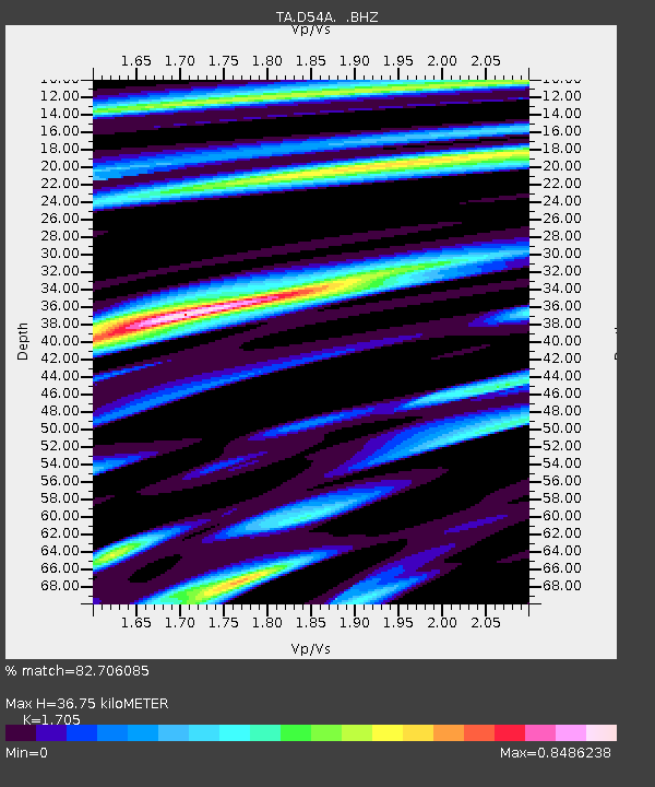
| Estimated Moho Depth: |
36.75 km |
| Estimated Crust Vp/Vs: |
1.71 |
| Assumed Crust Vp: |
6.622 km/s |
| Estimated Crust Vs: |
3.884 km/s |
| Estimated Crust Poisson's Ratio: |
0.24 |
|
| Radial Match: |
82.706085 % |
| Radial Bump: |
400 |
| Transverse Match: |
55.78018 % |
| Transverse Bump: |
400 |
| SOD ConfigId: |
512894 |
| Insert Time: |
2013-09-13 20:59:24.145 +0000 |
| GWidth: |
2.5 |
| Max Bumps: |
400 |
| Tol: |
0.001 |
|
Signal To Noise
| Channel | StoN | STA | LTA |
| TA:D54A: :BHZ:20130430T06:32:16.874996Z | 5.658505 | 5.703508E-7 | 1.0079531E-7 |
| TA:D54A: :BHN:20130430T06:32:16.874996Z | 1.2240977 | 9.357741E-8 | 7.644603E-8 |
| TA:D54A: :BHE:20130430T06:32:16.874996Z | 4.448587 | 3.3054E-7 | 7.430224E-8 |
| Arrivals |
| Ps | 4.2 SECOND |
| PpPs | 14 SECOND |
| PsPs/PpSs | 18 SECOND |


