You are here: Home > Network List > TA - USArray Transportable Network (new EarthScope stations) Stations List
> Station F40A Park Falls, WI, USA > Earthquake Result Viewer
F40A Park Falls, WI, USA - Earthquake Result Viewer

| Earthquake location: |
Azores Islands Region |
| Earthquake latitude/longitude: |
37.6/-24.9 |
| Earthquake time(UTC): |
2013/04/30 (120) 06:25:23 GMT |
| Earthquake Depth: |
10 km |
| Earthquake Magnitude: |
5.8 MW, 5.9 MW, 5.9 MB |
| Earthquake Catalog/Contributor: |
NEIC PDE/NEIC PDE-W |
|
| Network: |
TA USArray Transportable Network (new EarthScope stations) |
| Station: |
F40A Park Falls, WI, USA |
| Lat/Lon: |
45.92 N/90.12 W |
| Elevation: |
486 m |
|
| Distance: |
48.1 deg |
| Az: |
301.67 deg |
| Baz: |
75.57 deg |
| Ray Param: |
0.06955663 |
| Estimated Moho Depth: |
43.5 km |
| Estimated Crust Vp/Vs: |
1.65 |
| Assumed Crust Vp: |
6.571 km/s |
| Estimated Crust Vs: |
3.988 km/s |
| Estimated Crust Poisson's Ratio: |
0.21 |
|
| Radial Match: |
88.6311 % |
| Radial Bump: |
383 |
| Transverse Match: |
64.70642 % |
| Transverse Bump: |
400 |
| SOD ConfigId: |
512894 |
| Insert Time: |
2013-09-13 21:00:33.536 +0000 |
| GWidth: |
2.5 |
| Max Bumps: |
400 |
| Tol: |
0.001 |
|
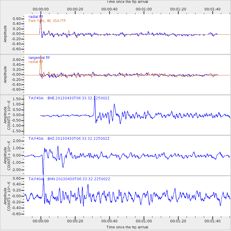
Signal To Noise
| Channel | StoN | STA | LTA |
| TA:F40A: :BHZ:20130430T06:33:32.225002Z | 9.472441 | 8.462916E-7 | 8.934251E-8 |
| TA:F40A: :BHN:20130430T06:33:32.225002Z | 2.751591 | 2.0837983E-7 | 7.5730675E-8 |
| TA:F40A: :BHE:20130430T06:33:32.225002Z | 13.279951 | 5.568729E-7 | 4.1933358E-8 |
| Arrivals |
| Ps | 4.6 SECOND |
| PpPs | 16 SECOND |
| PsPs/PpSs | 21 SECOND |


