You are here: Home > Network List > TA - USArray Transportable Network (new EarthScope stations) Stations List
> Station F48A Evansville, ON, CAN > Earthquake Result Viewer
F48A Evansville, ON, CAN - Earthquake Result Viewer
| Earthquake location: |
Azores Islands Region |
| Earthquake latitude/longitude: |
37.6/-24.9 |
| Earthquake time(UTC): |
2013/04/30 (120) 06:25:23 GMT |
| Earthquake Depth: |
10 km |
| Earthquake Magnitude: |
5.8 MW, 5.9 MW, 5.9 MB |
| Earthquake Catalog/Contributor: |
NEIC PDE/NEIC PDE-W |
|
| Network: |
TA USArray Transportable Network (new EarthScope stations) |
| Station: |
F48A Evansville, ON, CAN |
| Lat/Lon: |
45.83 N/82.62 W |
| Elevation: |
203 m |
|
| Distance: |
43.0 deg |
| Az: |
299.978 deg |
| Baz: |
79.756 deg |
| Ray Param: |
0.07281517 |
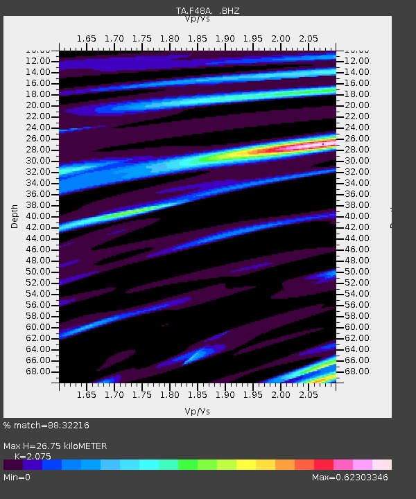
| Estimated Moho Depth: |
26.75 km |
| Estimated Crust Vp/Vs: |
2.08 |
| Assumed Crust Vp: |
6.483 km/s |
| Estimated Crust Vs: |
3.124 km/s |
| Estimated Crust Poisson's Ratio: |
0.35 |
|
| Radial Match: |
88.32216 % |
| Radial Bump: |
291 |
| Transverse Match: |
65.25269 % |
| Transverse Bump: |
400 |
| SOD ConfigId: |
512894 |
| Insert Time: |
2013-09-13 21:00:51.393 +0000 |
| GWidth: |
2.5 |
| Max Bumps: |
400 |
| Tol: |
0.001 |
|
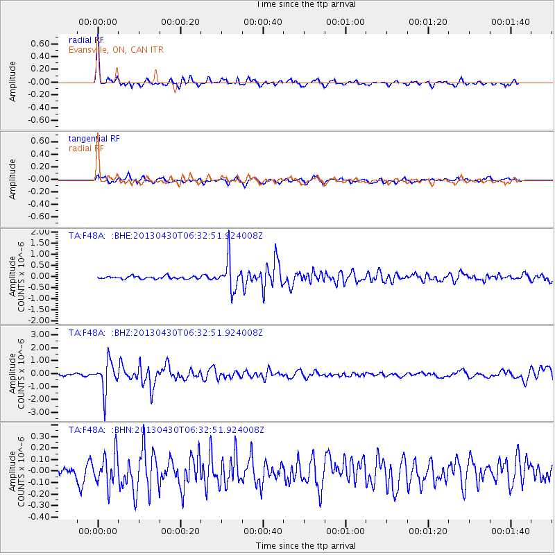
Signal To Noise
| Channel | StoN | STA | LTA |
| TA:F48A: :BHZ:20130430T06:32:51.924008Z | 12.052541 | 1.2263187E-6 | 1.0174773E-7 |
| TA:F48A: :BHN:20130430T06:32:51.924008Z | 2.015055 | 1.3891287E-7 | 6.89375E-8 |
| TA:F48A: :BHE:20130430T06:32:51.924008Z | 12.258675 | 6.98119E-7 | 5.6948977E-8 |
| Arrivals |
| Ps | 4.7 SECOND |
| PpPs | 12 SECOND |
| PsPs/PpSs | 17 SECOND |


