You are here: Home > Network List > TA - USArray Transportable Network (new EarthScope stations) Stations List
> Station G39A Holcombe, WI, USA > Earthquake Result Viewer
G39A Holcombe, WI, USA - Earthquake Result Viewer
| Earthquake location: |
Azores Islands Region |
| Earthquake latitude/longitude: |
37.6/-24.9 |
| Earthquake time(UTC): |
2013/04/30 (120) 06:25:23 GMT |
| Earthquake Depth: |
10 km |
| Earthquake Magnitude: |
5.8 MW, 5.9 MW, 5.9 MB |
| Earthquake Catalog/Contributor: |
NEIC PDE/NEIC PDE-W |
|
| Network: |
TA USArray Transportable Network (new EarthScope stations) |
| Station: |
G39A Holcombe, WI, USA |
| Lat/Lon: |
45.29 N/91.17 W |
| Elevation: |
350 m |
|
| Distance: |
49.0 deg |
| Az: |
301.109 deg |
| Baz: |
74.452 deg |
| Ray Param: |
0.06898495 |
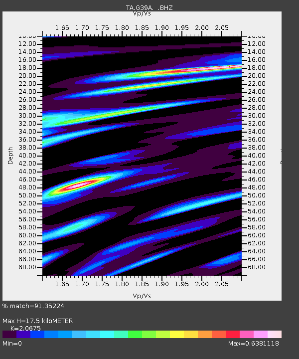
| Estimated Moho Depth: |
17.5 km |
| Estimated Crust Vp/Vs: |
2.07 |
| Assumed Crust Vp: |
6.571 km/s |
| Estimated Crust Vs: |
3.178 km/s |
| Estimated Crust Poisson's Ratio: |
0.35 |
|
| Radial Match: |
91.35224 % |
| Radial Bump: |
363 |
| Transverse Match: |
78.043655 % |
| Transverse Bump: |
400 |
| SOD ConfigId: |
512894 |
| Insert Time: |
2013-09-13 21:01:20.179 +0000 |
| GWidth: |
2.5 |
| Max Bumps: |
400 |
| Tol: |
0.001 |
|

Signal To Noise
| Channel | StoN | STA | LTA |
| TA:G39A: :BHZ:20130430T06:33:38.924008Z | 10.032594 | 9.341552E-7 | 9.3112035E-8 |
| TA:G39A: :BHN:20130430T06:33:38.924008Z | 2.658057 | 2.4868797E-7 | 9.356006E-8 |
| TA:G39A: :BHE:20130430T06:33:38.924008Z | 6.881563 | 5.7775E-7 | 8.395621E-8 |
| Arrivals |
| Ps | 3.0 SECOND |
| PpPs | 7.7 SECOND |
| PsPs/PpSs | 11 SECOND |


