You are here: Home > Network List > TA - USArray Transportable Network (new EarthScope stations) Stations List
> Station G45A Suttons Bay, MI, USA > Earthquake Result Viewer
G45A Suttons Bay, MI, USA - Earthquake Result Viewer
| Earthquake location: |
Azores Islands Region |
| Earthquake latitude/longitude: |
37.6/-24.9 |
| Earthquake time(UTC): |
2013/04/30 (120) 06:25:23 GMT |
| Earthquake Depth: |
10 km |
| Earthquake Magnitude: |
5.8 MW, 5.9 MW, 5.9 MB |
| Earthquake Catalog/Contributor: |
NEIC PDE/NEIC PDE-W |
|
| Network: |
TA USArray Transportable Network (new EarthScope stations) |
| Station: |
G45A Suttons Bay, MI, USA |
| Lat/Lon: |
45.04 N/85.66 W |
| Elevation: |
284 m |
|
| Distance: |
45.3 deg |
| Az: |
299.483 deg |
| Baz: |
77.243 deg |
| Ray Param: |
0.07138174 |
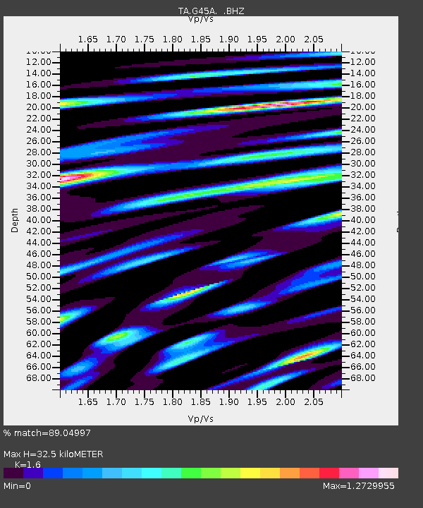
| Estimated Moho Depth: |
32.5 km |
| Estimated Crust Vp/Vs: |
1.60 |
| Assumed Crust Vp: |
6.483 km/s |
| Estimated Crust Vs: |
4.052 km/s |
| Estimated Crust Poisson's Ratio: |
0.18 |
|
| Radial Match: |
89.04997 % |
| Radial Bump: |
400 |
| Transverse Match: |
75.7479 % |
| Transverse Bump: |
400 |
| SOD ConfigId: |
512894 |
| Insert Time: |
2013-09-13 21:01:34.607 +0000 |
| GWidth: |
2.5 |
| Max Bumps: |
400 |
| Tol: |
0.001 |
|

Signal To Noise
| Channel | StoN | STA | LTA |
| TA:G45A: :BHZ:20130430T06:33:09.950009Z | 12.047545 | 1.293294E-6 | 1.0734916E-7 |
| TA:G45A: :BHN:20130430T06:33:09.950009Z | 4.967318 | 4.9472675E-7 | 9.959635E-8 |
| TA:G45A: :BHE:20130430T06:33:09.950009Z | 10.350991 | 1.1023781E-6 | 1.06499755E-7 |
| Arrivals |
| Ps | 3.2 SECOND |
| PpPs | 12 SECOND |
| PsPs/PpSs | 15 SECOND |


