You are here: Home > Network List > TA - USArray Transportable Network (new EarthScope stations) Stations List
> Station G47A Hillman, MI, USA > Earthquake Result Viewer
G47A Hillman, MI, USA - Earthquake Result Viewer
| Earthquake location: |
Azores Islands Region |
| Earthquake latitude/longitude: |
37.6/-24.9 |
| Earthquake time(UTC): |
2013/04/30 (120) 06:25:23 GMT |
| Earthquake Depth: |
10 km |
| Earthquake Magnitude: |
5.8 MW, 5.9 MW, 5.9 MB |
| Earthquake Catalog/Contributor: |
NEIC PDE/NEIC PDE-W |
|
| Network: |
TA USArray Transportable Network (new EarthScope stations) |
| Station: |
G47A Hillman, MI, USA |
| Lat/Lon: |
45.17 N/83.86 W |
| Elevation: |
239 m |
|
| Distance: |
44.0 deg |
| Az: |
299.284 deg |
| Baz: |
78.374 deg |
| Ray Param: |
0.07218262 |
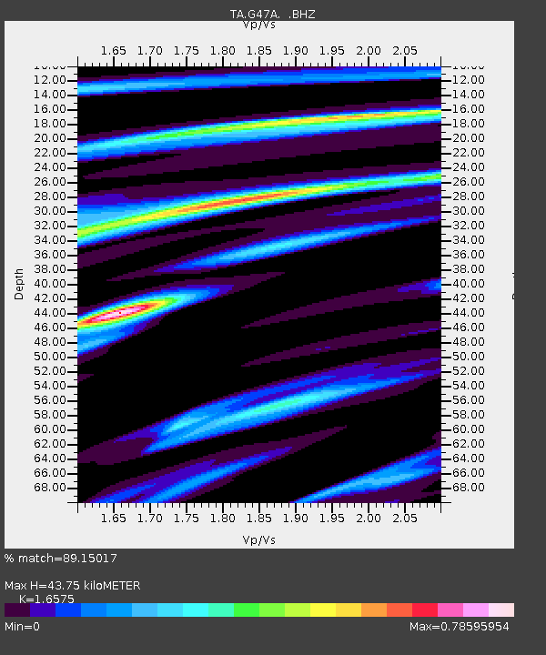
| Estimated Moho Depth: |
43.75 km |
| Estimated Crust Vp/Vs: |
1.66 |
| Assumed Crust Vp: |
6.483 km/s |
| Estimated Crust Vs: |
3.911 km/s |
| Estimated Crust Poisson's Ratio: |
0.21 |
|
| Radial Match: |
89.15017 % |
| Radial Bump: |
319 |
| Transverse Match: |
75.91311 % |
| Transverse Bump: |
400 |
| SOD ConfigId: |
512894 |
| Insert Time: |
2013-09-13 21:01:40.867 +0000 |
| GWidth: |
2.5 |
| Max Bumps: |
400 |
| Tol: |
0.001 |
|
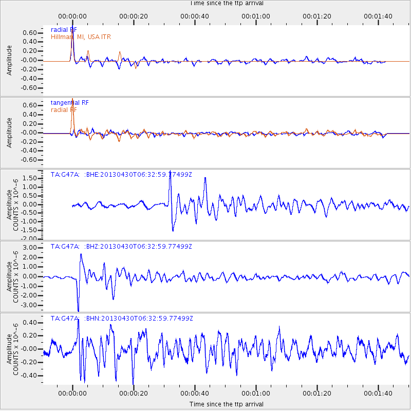
Signal To Noise
| Channel | StoN | STA | LTA |
| TA:G47A: :BHZ:20130430T06:32:59.77499Z | 10.223561 | 1.3587529E-6 | 1.3290408E-7 |
| TA:G47A: :BHN:20130430T06:32:59.77499Z | 3.6126852 | 2.28966E-7 | 6.3378344E-8 |
| TA:G47A: :BHE:20130430T06:32:59.77499Z | 7.572425 | 8.3000174E-7 | 1.0960844E-7 |
| Arrivals |
| Ps | 4.8 SECOND |
| PpPs | 17 SECOND |
| PsPs/PpSs | 21 SECOND |


