You are here: Home > Network List > TA - USArray Transportable Network (new EarthScope stations) Stations List
> Station G53A Haliburton, ON, CAN > Earthquake Result Viewer
G53A Haliburton, ON, CAN - Earthquake Result Viewer
| Earthquake location: |
Azores Islands Region |
| Earthquake latitude/longitude: |
37.6/-24.9 |
| Earthquake time(UTC): |
2013/04/30 (120) 06:25:23 GMT |
| Earthquake Depth: |
10 km |
| Earthquake Magnitude: |
5.8 MW, 5.9 MW, 5.9 MB |
| Earthquake Catalog/Contributor: |
NEIC PDE/NEIC PDE-W |
|
| Network: |
TA USArray Transportable Network (new EarthScope stations) |
| Station: |
G53A Haliburton, ON, CAN |
| Lat/Lon: |
45.12 N/78.62 W |
| Elevation: |
333 m |
|
| Distance: |
40.4 deg |
| Az: |
298.237 deg |
| Baz: |
81.295 deg |
| Ray Param: |
0.07443856 |
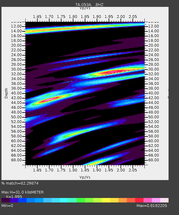
| Estimated Moho Depth: |
31.0 km |
| Estimated Crust Vp/Vs: |
2.00 |
| Assumed Crust Vp: |
6.577 km/s |
| Estimated Crust Vs: |
3.297 km/s |
| Estimated Crust Poisson's Ratio: |
0.33 |
|
| Radial Match: |
82.29874 % |
| Radial Bump: |
354 |
| Transverse Match: |
63.662647 % |
| Transverse Bump: |
400 |
| SOD ConfigId: |
512894 |
| Insert Time: |
2013-09-13 21:01:43.870 +0000 |
| GWidth: |
2.5 |
| Max Bumps: |
400 |
| Tol: |
0.001 |
|

Signal To Noise
| Channel | StoN | STA | LTA |
| TA:G53A: :BHZ:20130430T06:32:30.199001Z | 7.567569 | 7.309863E-7 | 9.6594604E-8 |
| TA:G53A: :BHN:20130430T06:32:30.199001Z | 2.7952254 | 1.515054E-7 | 5.42015E-8 |
| TA:G53A: :BHE:20130430T06:32:30.199001Z | 5.656346 | 3.829924E-7 | 6.771022E-8 |
| Arrivals |
| Ps | 5.0 SECOND |
| PpPs | 13 SECOND |
| PsPs/PpSs | 18 SECOND |


