You are here: Home > Network List > TA - USArray Transportable Network (new EarthScope stations) Stations List
> Station I40A Norwalk, WI, USA > Earthquake Result Viewer
I40A Norwalk, WI, USA - Earthquake Result Viewer
| Earthquake location: |
Azores Islands Region |
| Earthquake latitude/longitude: |
37.6/-24.9 |
| Earthquake time(UTC): |
2013/04/30 (120) 06:25:23 GMT |
| Earthquake Depth: |
10 km |
| Earthquake Magnitude: |
5.8 MW, 5.9 MW, 5.9 MB |
| Earthquake Catalog/Contributor: |
NEIC PDE/NEIC PDE-W |
|
| Network: |
TA USArray Transportable Network (new EarthScope stations) |
| Station: |
I40A Norwalk, WI, USA |
| Lat/Lon: |
43.89 N/90.62 W |
| Elevation: |
419 m |
|
| Distance: |
49.0 deg |
| Az: |
299.189 deg |
| Baz: |
73.578 deg |
| Ray Param: |
0.06898167 |
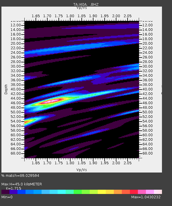
| Estimated Moho Depth: |
45.0 km |
| Estimated Crust Vp/Vs: |
1.72 |
| Assumed Crust Vp: |
6.53 km/s |
| Estimated Crust Vs: |
3.808 km/s |
| Estimated Crust Poisson's Ratio: |
0.24 |
|
| Radial Match: |
89.029594 % |
| Radial Bump: |
400 |
| Transverse Match: |
72.45112 % |
| Transverse Bump: |
400 |
| SOD ConfigId: |
512894 |
| Insert Time: |
2013-09-13 21:03:00.541 +0000 |
| GWidth: |
2.5 |
| Max Bumps: |
400 |
| Tol: |
0.001 |
|

Signal To Noise
| Channel | StoN | STA | LTA |
| TA:I40A: :BHZ:20130430T06:33:38.975002Z | 11.377111 | 9.47935E-7 | 8.331948E-8 |
| TA:I40A: :BHN:20130430T06:33:38.975002Z | 1.7906109 | 1.389342E-7 | 7.759039E-8 |
| TA:I40A: :BHE:20130430T06:33:38.975002Z | 7.638197 | 5.598886E-7 | 7.3301145E-8 |
| Arrivals |
| Ps | 5.3 SECOND |
| PpPs | 18 SECOND |
| PsPs/PpSs | 23 SECOND |


