You are here: Home > Network List > PS - Pacific21 Stations List
> Station PSI Parapat, Indonesia > Earthquake Result Viewer
PSI Parapat, Indonesia - Earthquake Result Viewer
| Earthquake location: |
Vanuatu Islands |
| Earthquake latitude/longitude: |
-19.5/169.2 |
| Earthquake time(UTC): |
1995/06/29 (180) 12:24:03 GMT |
| Earthquake Depth: |
144 km |
| Earthquake Magnitude: |
6.2 MB, 6.7 UNKNOWN, 6.6 MW |
| Earthquake Catalog/Contributor: |
WHDF/NEIC |
|
| Network: |
PS Pacific21 |
| Station: |
PSI Parapat, Indonesia |
| Lat/Lon: |
2.69 N/98.92 E |
| Elevation: |
987 m |
|
| Distance: |
72.4 deg |
| Az: |
279.387 deg |
| Baz: |
111.262 deg |
| Ray Param: |
0.053302526 |
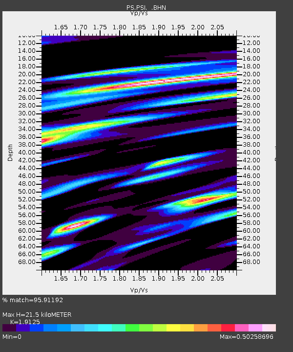
| Estimated Moho Depth: |
21.5 km |
| Estimated Crust Vp/Vs: |
1.91 |
| Assumed Crust Vp: |
6.468 km/s |
| Estimated Crust Vs: |
3.382 km/s |
| Estimated Crust Poisson's Ratio: |
0.31 |
|
| Radial Match: |
95.91192 % |
| Radial Bump: |
400 |
| Transverse Match: |
95.24481 % |
| Transverse Bump: |
400 |
| SOD ConfigId: |
6273 |
| Insert Time: |
2010-02-27 03:23:52.430 +0000 |
| GWidth: |
2.5 |
| Max Bumps: |
400 |
| Tol: |
0.001 |
|

Signal To Noise
| Channel | StoN | STA | LTA |
| PS:PSI: :BHN:19950629T12:34:43.550024Z | 15.230773 | 4.536145E-7 | 2.9782763E-8 |
| PS:PSI: :BHE:19950629T12:34:43.550024Z | 11.14311 | 8.5853316E-7 | 7.7046096E-8 |
| PS:PSI: :BHZ:19950629T12:34:43.550024Z | 40.023716 | 2.0941056E-6 | 5.232162E-8 |
| Arrivals |
| Ps | 3.1 SECOND |
| PpPs | 9.4 SECOND |
| PsPs/PpSs | 13 SECOND |


