You are here: Home > Network List > TA - USArray Transportable Network (new EarthScope stations) Stations List
> Station J40A Soldiers Grove, WI, USA > Earthquake Result Viewer
J40A Soldiers Grove, WI, USA - Earthquake Result Viewer
| Earthquake location: |
Azores Islands Region |
| Earthquake latitude/longitude: |
37.6/-24.9 |
| Earthquake time(UTC): |
2013/04/30 (120) 06:25:23 GMT |
| Earthquake Depth: |
10 km |
| Earthquake Magnitude: |
5.8 MW, 5.9 MW, 5.9 MB |
| Earthquake Catalog/Contributor: |
NEIC PDE/NEIC PDE-W |
|
| Network: |
TA USArray Transportable Network (new EarthScope stations) |
| Station: |
J40A Soldiers Grove, WI, USA |
| Lat/Lon: |
43.40 N/90.74 W |
| Elevation: |
353 m |
|
| Distance: |
49.2 deg |
| Az: |
298.595 deg |
| Baz: |
73.105 deg |
| Ray Param: |
0.068829834 |
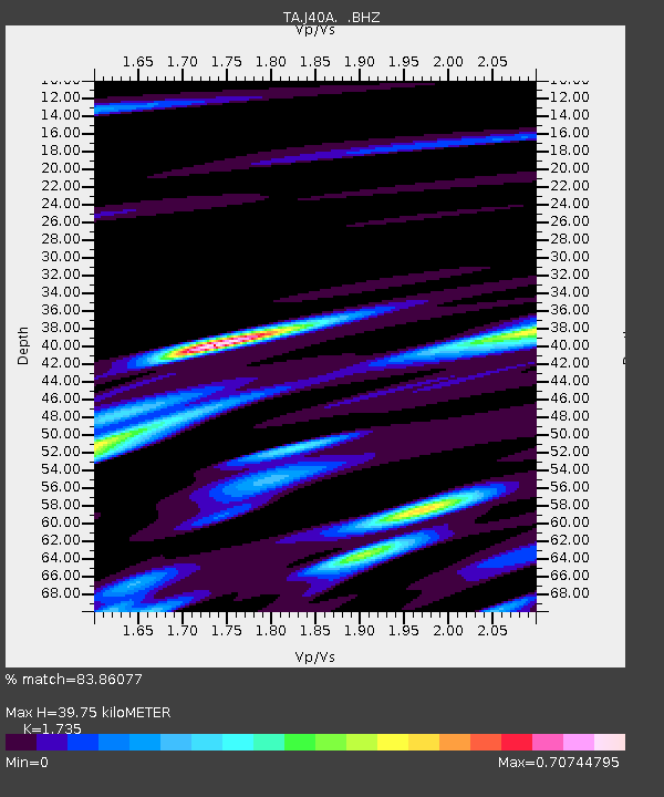
| Estimated Moho Depth: |
39.75 km |
| Estimated Crust Vp/Vs: |
1.74 |
| Assumed Crust Vp: |
6.53 km/s |
| Estimated Crust Vs: |
3.764 km/s |
| Estimated Crust Poisson's Ratio: |
0.25 |
|
| Radial Match: |
83.86077 % |
| Radial Bump: |
400 |
| Transverse Match: |
41.536133 % |
| Transverse Bump: |
400 |
| SOD ConfigId: |
512894 |
| Insert Time: |
2013-09-13 21:03:53.954 +0000 |
| GWidth: |
2.5 |
| Max Bumps: |
400 |
| Tol: |
0.001 |
|

Signal To Noise
| Channel | StoN | STA | LTA |
| TA:J40A: :BHZ:20130430T06:33:40.699001Z | 10.87294 | 8.8721873E-7 | 8.1598785E-8 |
| TA:J40A: :BHN:20130430T06:33:40.699001Z | 1.7709088 | 2.257441E-7 | 1.2747358E-7 |
| TA:J40A: :BHE:20130430T06:33:40.699001Z | 5.679555 | 5.369261E-7 | 9.453665E-8 |
| Arrivals |
| Ps | 4.8 SECOND |
| PpPs | 16 SECOND |
| PsPs/PpSs | 20 SECOND |


