You are here: Home > Network List > CN - Canadian National Seismograph Network Stations List
> Station INK INUVIK, NT > Earthquake Result Viewer
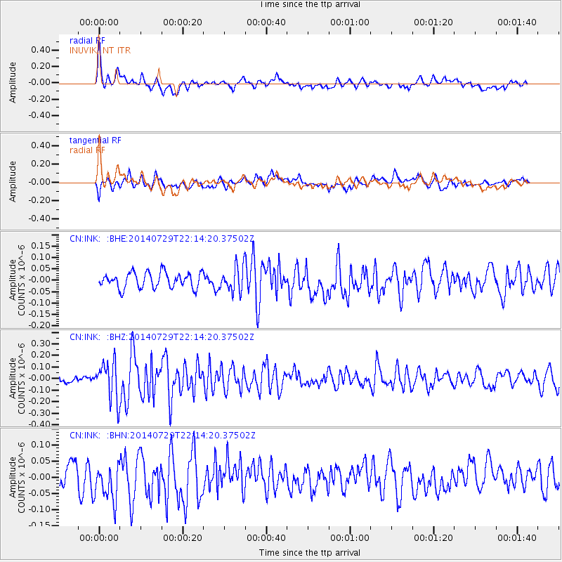
INK INUVIK, NT - Earthquake Result Viewer
*The percent match for this event was below the threshold and hence no stack was calculated.
| Earthquake location: |
Northern Mid-Atlantic Ridge |
| Earthquake latitude/longitude: |
35.1/-36.3 |
| Earthquake time(UTC): |
2014/07/29 (210) 22:04:40 GMT |
| Earthquake Depth: |
0.0 km |
| Earthquake Magnitude: |
5.6 MW, 4.8 ms1mx, 4.9 Ms1, 4.8 MS, 4.5 mbtmp, 4.5 mb1mx, 4.6 mb1, 4.5 mb |
| Earthquake Catalog/Contributor: |
ISC/ISC |
|
| Network: |
CN Canadian National Seismograph Network |
| Station: |
INK INUVIK, NT |
| Lat/Lon: |
68.31 N/133.53 W |
| Elevation: |
44 m |
|
| Distance: |
60.4 deg |
| Az: |
334.91 deg |
| Baz: |
69.217 deg |
| Ray Param: |
$rayparam |
*The percent match for this event was below the threshold and hence was not used in the summary stack. |
|
| Radial Match: |
69.664314 % |
| Radial Bump: |
400 |
| Transverse Match: |
48.541035 % |
| Transverse Bump: |
400 |
| SOD ConfigId: |
3390531 |
| Insert Time: |
2019-04-13 02:24:33.033 +0000 |
| GWidth: |
2.5 |
| Max Bumps: |
400 |
| Tol: |
0.001 |
|
Signal To Noise
| Channel | StoN | STA | LTA |
| CN:INK: :BHZ:20140729T22:14:20.37502Z | 4.5239005 | 1.6694335E-7 | 3.6902527E-8 |
| CN:INK: :BHN:20140729T22:14:20.37502Z | 1.0584925 | 5.7539697E-8 | 5.4360044E-8 |
| CN:INK: :BHE:20140729T22:14:20.37502Z | 1.6637526 | 5.6227574E-8 | 3.3795637E-8 |
| Arrivals |
| Ps | |
| PpPs | |
| PsPs/PpSs | |


