You are here: Home > Network List > TA - USArray Transportable Network (new EarthScope stations) Stations List
> Station J47A Sunmer, MI, USA > Earthquake Result Viewer
J47A Sunmer, MI, USA - Earthquake Result Viewer
| Earthquake location: |
Azores Islands Region |
| Earthquake latitude/longitude: |
37.6/-24.9 |
| Earthquake time(UTC): |
2013/04/30 (120) 06:25:23 GMT |
| Earthquake Depth: |
10 km |
| Earthquake Magnitude: |
5.8 MW, 5.9 MW, 5.9 MB |
| Earthquake Catalog/Contributor: |
NEIC PDE/NEIC PDE-W |
|
| Network: |
TA USArray Transportable Network (new EarthScope stations) |
| Station: |
J47A Sunmer, MI, USA |
| Lat/Lon: |
43.24 N/84.82 W |
| Elevation: |
236 m |
|
| Distance: |
45.1 deg |
| Az: |
296.817 deg |
| Baz: |
75.944 deg |
| Ray Param: |
0.07149237 |
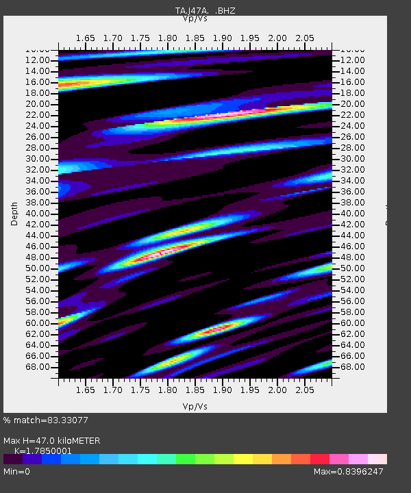
| Estimated Moho Depth: |
47.0 km |
| Estimated Crust Vp/Vs: |
1.79 |
| Assumed Crust Vp: |
6.483 km/s |
| Estimated Crust Vs: |
3.632 km/s |
| Estimated Crust Poisson's Ratio: |
0.27 |
|
| Radial Match: |
83.33077 % |
| Radial Bump: |
400 |
| Transverse Match: |
66.6781 % |
| Transverse Bump: |
400 |
| SOD ConfigId: |
512894 |
| Insert Time: |
2013-09-13 21:04:11.995 +0000 |
| GWidth: |
2.5 |
| Max Bumps: |
400 |
| Tol: |
0.001 |
|

Signal To Noise
| Channel | StoN | STA | LTA |
| TA:J47A: :BHZ:20130430T06:33:08.624996Z | 10.421468 | 1.2382211E-6 | 1.1881446E-7 |
| TA:J47A: :BHN:20130430T06:33:08.624996Z | 2.11796 | 2.4917017E-7 | 1.1764631E-7 |
| TA:J47A: :BHE:20130430T06:33:08.624996Z | 5.974776 | 8.0293773E-7 | 1.3438793E-7 |
| Arrivals |
| Ps | 6.1 SECOND |
| PpPs | 19 SECOND |
| PsPs/PpSs | 25 SECOND |


