You are here: Home > Network List > TA - USArray Transportable Network (new EarthScope stations) Stations List
> Station K47A Vremontville, MI, USA > Earthquake Result Viewer
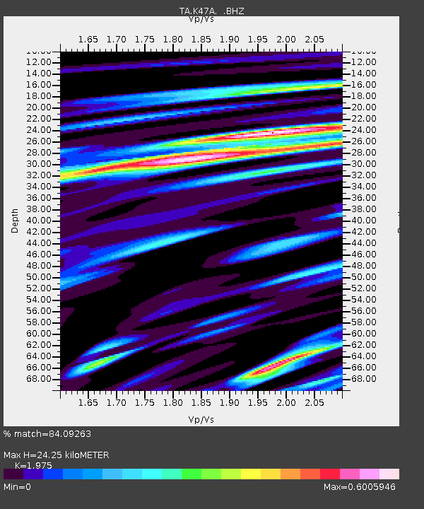
K47A Vremontville, MI, USA - Earthquake Result Viewer
| Earthquake location: |
Azores Islands Region |
| Earthquake latitude/longitude: |
37.6/-24.9 |
| Earthquake time(UTC): |
2013/04/30 (120) 06:25:23 GMT |
| Earthquake Depth: |
10 km |
| Earthquake Magnitude: |
5.8 MW, 5.9 MW, 5.9 MB |
| Earthquake Catalog/Contributor: |
NEIC PDE/NEIC PDE-W |
|
| Network: |
TA USArray Transportable Network (new EarthScope stations) |
| Station: |
K47A Vremontville, MI, USA |
| Lat/Lon: |
42.67 N/85.00 W |
| Elevation: |
275 m |
|
| Distance: |
45.4 deg |
| Az: |
296.088 deg |
| Baz: |
75.31 deg |
| Ray Param: |
0.07131586 |
| Estimated Moho Depth: |
24.25 km |
| Estimated Crust Vp/Vs: |
1.98 |
| Assumed Crust Vp: |
6.483 km/s |
| Estimated Crust Vs: |
3.282 km/s |
| Estimated Crust Poisson's Ratio: |
0.33 |
|
| Radial Match: |
84.09263 % |
| Radial Bump: |
314 |
| Transverse Match: |
61.088688 % |
| Transverse Bump: |
381 |
| SOD ConfigId: |
512894 |
| Insert Time: |
2013-09-13 21:04:57.898 +0000 |
| GWidth: |
2.5 |
| Max Bumps: |
400 |
| Tol: |
0.001 |
|

Signal To Noise
| Channel | StoN | STA | LTA |
| TA:K47A: :BHZ:20130430T06:33:10.749996Z | 8.01621 | 1.2724885E-6 | 1.5873943E-7 |
| TA:K47A: :BHN:20130430T06:33:10.749996Z | 2.1533394 | 2.6447876E-7 | 1.2282261E-7 |
| TA:K47A: :BHE:20130430T06:33:10.749996Z | 7.2497354 | 7.370645E-7 | 1.0166778E-7 |
| Arrivals |
| Ps | 3.9 SECOND |
| PpPs | 10 SECOND |
| PsPs/PpSs | 14 SECOND |


