You are here: Home > Network List > TA - USArray Transportable Network (new EarthScope stations) Stations List
> Station K48A Perry, MI, USA > Earthquake Result Viewer
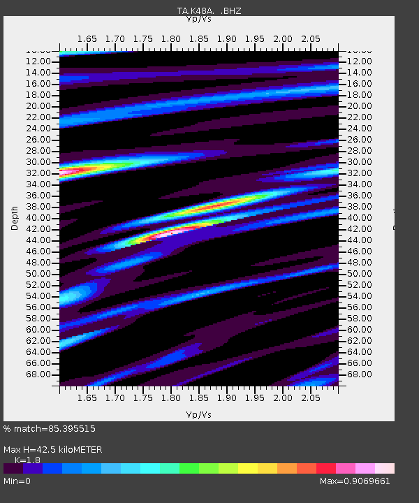
K48A Perry, MI, USA - Earthquake Result Viewer
| Earthquake location: |
Azores Islands Region |
| Earthquake latitude/longitude: |
37.6/-24.9 |
| Earthquake time(UTC): |
2013/04/30 (120) 06:25:23 GMT |
| Earthquake Depth: |
10 km |
| Earthquake Magnitude: |
5.8 MW, 5.9 MW, 5.9 MB |
| Earthquake Catalog/Contributor: |
NEIC PDE/NEIC PDE-W |
|
| Network: |
TA USArray Transportable Network (new EarthScope stations) |
| Station: |
K48A Perry, MI, USA |
| Lat/Lon: |
42.80 N/84.12 W |
| Elevation: |
273 m |
|
| Distance: |
44.7 deg |
| Az: |
296.042 deg |
| Baz: |
75.872 deg |
| Ray Param: |
0.071742885 |
| Estimated Moho Depth: |
42.5 km |
| Estimated Crust Vp/Vs: |
1.80 |
| Assumed Crust Vp: |
6.483 km/s |
| Estimated Crust Vs: |
3.601 km/s |
| Estimated Crust Poisson's Ratio: |
0.28 |
|
| Radial Match: |
85.395515 % |
| Radial Bump: |
400 |
| Transverse Match: |
68.039375 % |
| Transverse Bump: |
400 |
| SOD ConfigId: |
512894 |
| Insert Time: |
2013-09-13 21:05:02.179 +0000 |
| GWidth: |
2.5 |
| Max Bumps: |
400 |
| Tol: |
0.001 |
|

Signal To Noise
| Channel | StoN | STA | LTA |
| TA:K48A: :BHZ:20130430T06:33:05.498989Z | 16.920193 | 1.1829054E-6 | 6.991087E-8 |
| TA:K48A: :BHN:20130430T06:33:05.498989Z | 1.866217 | 1.7633833E-7 | 9.448972E-8 |
| TA:K48A: :BHE:20130430T06:33:05.498989Z | 7.536368 | 5.51909E-7 | 7.3232755E-8 |
| Arrivals |
| Ps | 5.6 SECOND |
| PpPs | 17 SECOND |
| PsPs/PpSs | 23 SECOND |


