You are here: Home > Network List > TA - USArray Transportable Network (new EarthScope stations) Stations List
> Station L43A Garden Prairie, IL, USA > Earthquake Result Viewer
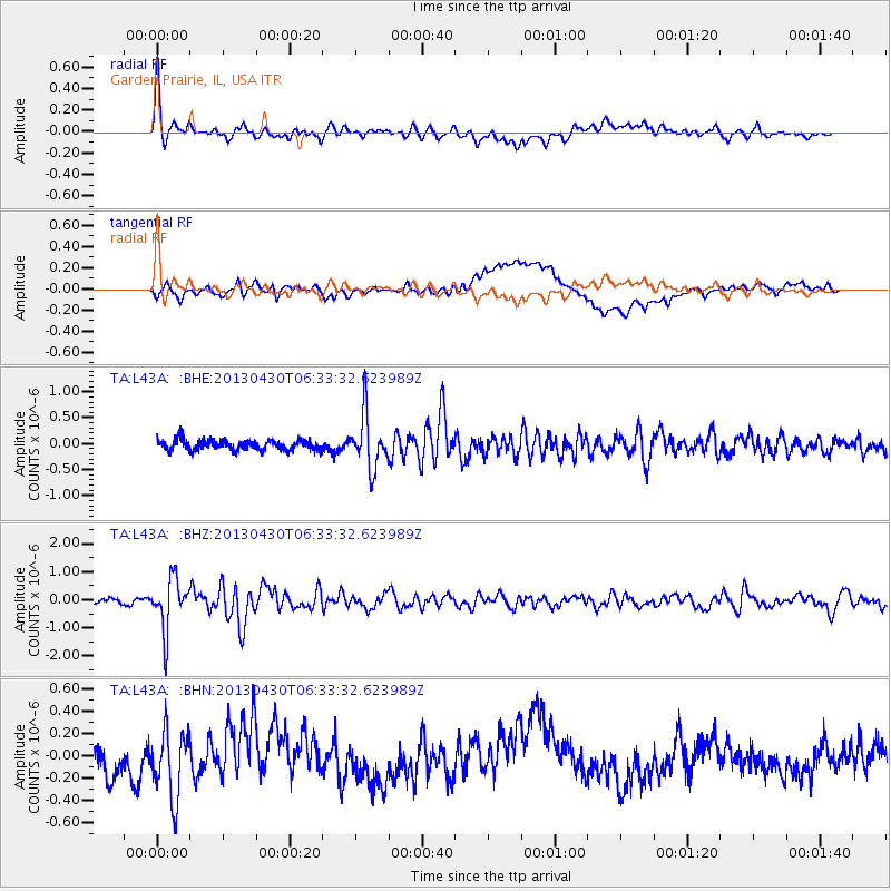
L43A Garden Prairie, IL, USA - Earthquake Result Viewer
*The percent match for this event was below the threshold and hence no stack was calculated.
| Earthquake location: |
Azores Islands Region |
| Earthquake latitude/longitude: |
37.6/-24.9 |
| Earthquake time(UTC): |
2013/04/30 (120) 06:25:23 GMT |
| Earthquake Depth: |
10 km |
| Earthquake Magnitude: |
5.8 MW, 5.9 MW, 5.9 MB |
| Earthquake Catalog/Contributor: |
NEIC PDE/NEIC PDE-W |
|
| Network: |
TA USArray Transportable Network (new EarthScope stations) |
| Station: |
L43A Garden Prairie, IL, USA |
| Lat/Lon: |
42.18 N/88.74 W |
| Elevation: |
266 m |
|
| Distance: |
48.2 deg |
| Az: |
296.482 deg |
| Baz: |
73.063 deg |
| Ray Param: |
$rayparam |
*The percent match for this event was below the threshold and hence was not used in the summary stack. |
|
| Radial Match: |
79.727776 % |
| Radial Bump: |
400 |
| Transverse Match: |
51.305084 % |
| Transverse Bump: |
400 |
| SOD ConfigId: |
512894 |
| Insert Time: |
2013-09-13 21:05:40.606 +0000 |
| GWidth: |
2.5 |
| Max Bumps: |
400 |
| Tol: |
0.001 |
|
Signal To Noise
| Channel | StoN | STA | LTA |
| TA:L43A: :BHZ:20130430T06:33:32.623989Z | 8.603801 | 9.1767873E-7 | 1.0665969E-7 |
| TA:L43A: :BHN:20130430T06:33:32.623989Z | 1.1183944 | 3.2942043E-7 | 2.9454765E-7 |
| TA:L43A: :BHE:20130430T06:33:32.623989Z | 5.2276454 | 5.197048E-7 | 9.9414706E-8 |
| Arrivals |
| Ps | |
| PpPs | |
| PsPs/PpSs | |


