You are here: Home > Network List > TA - USArray Transportable Network (new EarthScope stations) Stations List
> Station L50A Kingsville, ON, CAN > Earthquake Result Viewer
L50A Kingsville, ON, CAN - Earthquake Result Viewer

| Earthquake location: |
Azores Islands Region |
| Earthquake latitude/longitude: |
37.6/-24.9 |
| Earthquake time(UTC): |
2013/04/30 (120) 06:25:23 GMT |
| Earthquake Depth: |
10 km |
| Earthquake Magnitude: |
5.8 MW, 5.9 MW, 5.9 MB |
| Earthquake Catalog/Contributor: |
NEIC PDE/NEIC PDE-W |
|
| Network: |
TA USArray Transportable Network (new EarthScope stations) |
| Station: |
L50A Kingsville, ON, CAN |
| Lat/Lon: |
42.04 N/82.81 W |
| Elevation: |
187 m |
|
| Distance: |
44.0 deg |
| Az: |
294.648 deg |
| Baz: |
75.756 deg |
| Ray Param: |
0.07220839 |
| Estimated Moho Depth: |
15.25 km |
| Estimated Crust Vp/Vs: |
1.86 |
| Assumed Crust Vp: |
6.483 km/s |
| Estimated Crust Vs: |
3.495 km/s |
| Estimated Crust Poisson's Ratio: |
0.30 |
|
| Radial Match: |
81.256256 % |
| Radial Bump: |
400 |
| Transverse Match: |
68.91409 % |
| Transverse Bump: |
400 |
| SOD ConfigId: |
512894 |
| Insert Time: |
2013-09-13 21:05:56.679 +0000 |
| GWidth: |
2.5 |
| Max Bumps: |
400 |
| Tol: |
0.001 |
|
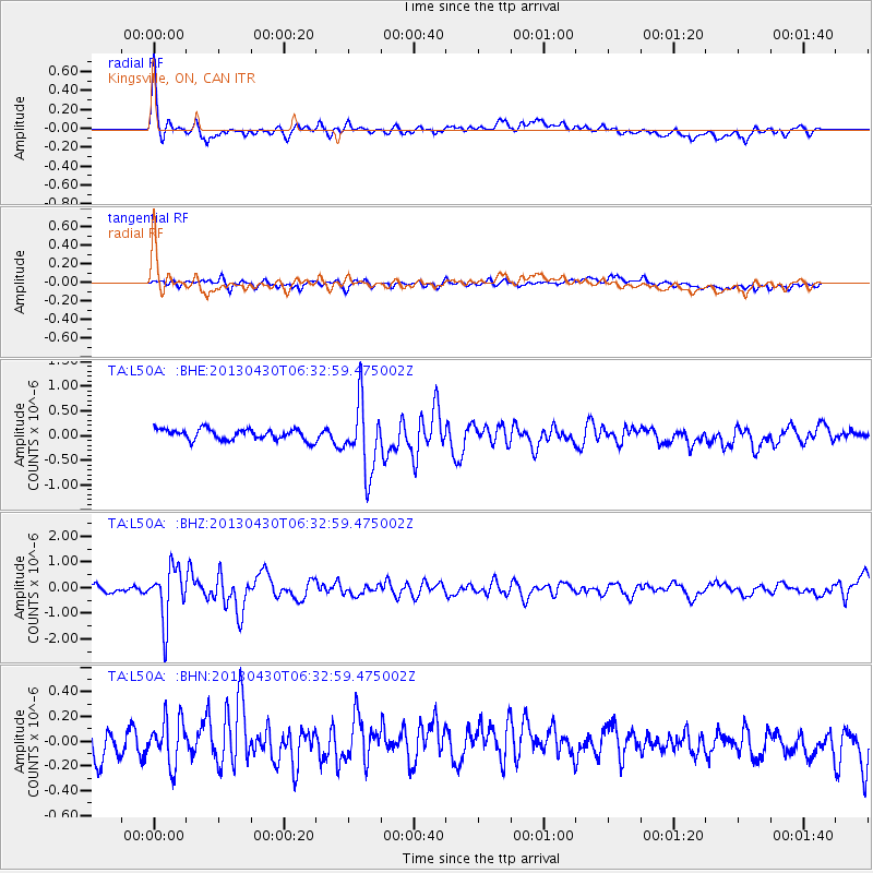
Signal To Noise
| Channel | StoN | STA | LTA |
| TA:L50A: :BHZ:20130430T06:32:59.475002Z | 10.154307 | 1.0225298E-6 | 1.0069911E-7 |
| TA:L50A: :BHN:20130430T06:32:59.475002Z | 1.6874871 | 1.8510623E-7 | 1.0969341E-7 |
| TA:L50A: :BHE:20130430T06:32:59.475002Z | 6.363058 | 6.937249E-7 | 1.0902382E-7 |
| Arrivals |
| Ps | 2.1 SECOND |
| PpPs | 6.3 SECOND |
| PsPs/PpSs | 8.4 SECOND |


