You are here: Home > Network List > PS - Pacific21 Stations List
> Station PSI Parapat, Indonesia > Earthquake Result Viewer
PSI Parapat, Indonesia - Earthquake Result Viewer
| Earthquake location: |
Solomon Islands |
| Earthquake latitude/longitude: |
-6.5/154.5 |
| Earthquake time(UTC): |
1995/10/15 (288) 15:04:13 GMT |
| Earthquake Depth: |
52 km |
| Earthquake Magnitude: |
5.3 MB, 5.9 MS, 5.9 UNKNOWN, 6.1 MW |
| Earthquake Catalog/Contributor: |
WHDF/NEIC |
|
| Network: |
PS Pacific21 |
| Station: |
PSI Parapat, Indonesia |
| Lat/Lon: |
2.69 N/98.92 E |
| Elevation: |
987 m |
|
| Distance: |
56.3 deg |
| Az: |
277.618 deg |
| Baz: |
99.639 deg |
| Ray Param: |
0.06413078 |
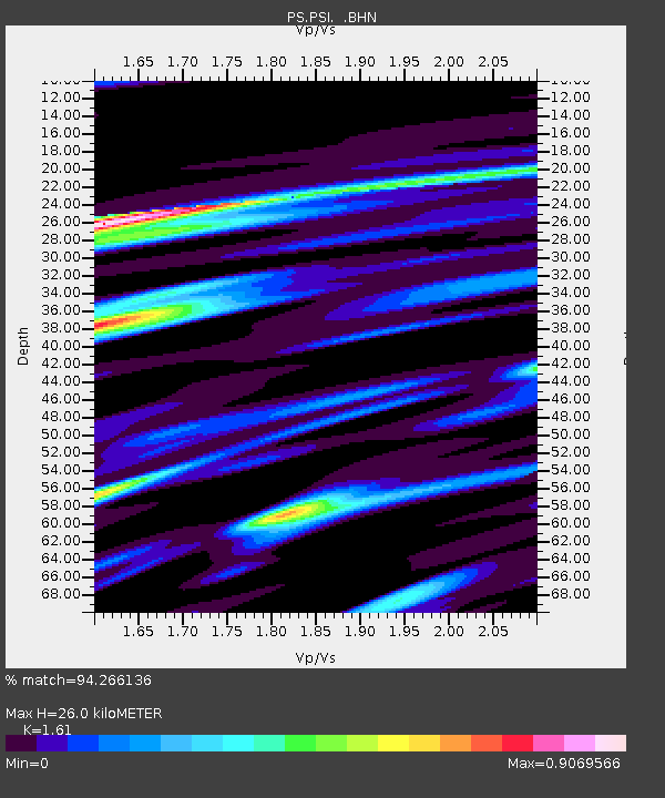
| Estimated Moho Depth: |
26.0 km |
| Estimated Crust Vp/Vs: |
1.61 |
| Assumed Crust Vp: |
6.468 km/s |
| Estimated Crust Vs: |
4.017 km/s |
| Estimated Crust Poisson's Ratio: |
0.19 |
|
| Radial Match: |
94.266136 % |
| Radial Bump: |
337 |
| Transverse Match: |
87.74271 % |
| Transverse Bump: |
400 |
| SOD ConfigId: |
6273 |
| Insert Time: |
2010-02-27 03:24:07.345 +0000 |
| GWidth: |
2.5 |
| Max Bumps: |
400 |
| Tol: |
0.001 |
|
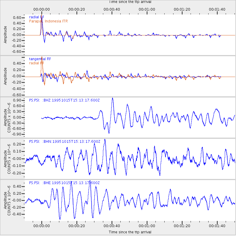
Signal To Noise
| Channel | StoN | STA | LTA |
| PS:PSI: :BHN:19951015T15:13:17.600Z | 1.8599632 | 4.7710778E-8 | 2.5651463E-8 |
| PS:PSI: :BHE:19951015T15:13:17.600Z | 2.8741002 | 9.390433E-8 | 3.2672602E-8 |
| PS:PSI: :BHZ:19951015T15:13:17.600Z | 5.936363 | 1.9477056E-7 | 3.2809744E-8 |
| Arrivals |
| Ps | 2.6 SECOND |
| PpPs | 9.9 SECOND |
| PsPs/PpSs | 13 SECOND |


