You are here: Home > Network List > TA - USArray Transportable Network (new EarthScope stations) Stations List
> Station L53A Girard, PA, USA > Earthquake Result Viewer
L53A Girard, PA, USA - Earthquake Result Viewer
| Earthquake location: |
Azores Islands Region |
| Earthquake latitude/longitude: |
37.6/-24.9 |
| Earthquake time(UTC): |
2013/04/30 (120) 06:25:23 GMT |
| Earthquake Depth: |
10 km |
| Earthquake Magnitude: |
5.8 MW, 5.9 MW, 5.9 MB |
| Earthquake Catalog/Contributor: |
NEIC PDE/NEIC PDE-W |
|
| Network: |
TA USArray Transportable Network (new EarthScope stations) |
| Station: |
L53A Girard, PA, USA |
| Lat/Lon: |
41.95 N/80.26 W |
| Elevation: |
355 m |
|
| Distance: |
42.1 deg |
| Az: |
293.863 deg |
| Baz: |
76.882 deg |
| Ray Param: |
0.07334586 |
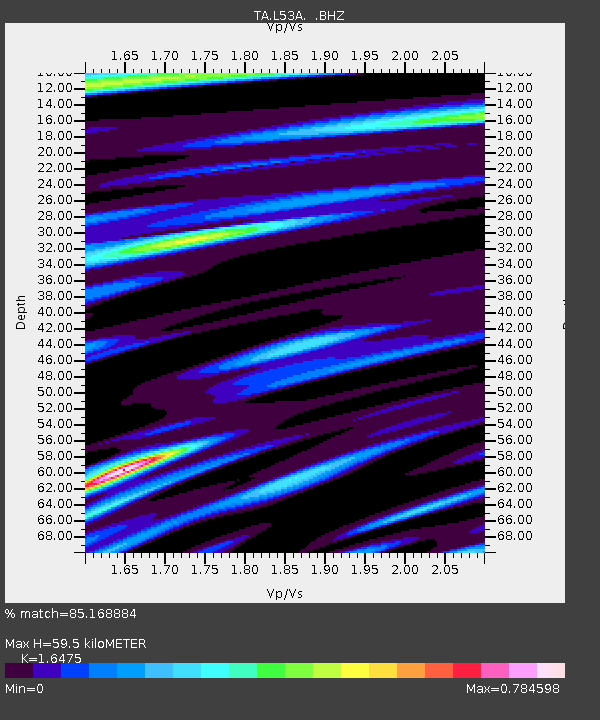
| Estimated Moho Depth: |
59.5 km |
| Estimated Crust Vp/Vs: |
1.65 |
| Assumed Crust Vp: |
6.483 km/s |
| Estimated Crust Vs: |
3.935 km/s |
| Estimated Crust Poisson's Ratio: |
0.21 |
|
| Radial Match: |
85.168884 % |
| Radial Bump: |
305 |
| Transverse Match: |
62.99591 % |
| Transverse Bump: |
352 |
| SOD ConfigId: |
512894 |
| Insert Time: |
2013-09-13 21:05:57.567 +0000 |
| GWidth: |
2.5 |
| Max Bumps: |
400 |
| Tol: |
0.001 |
|

Signal To Noise
| Channel | StoN | STA | LTA |
| TA:L53A: :BHZ:20130430T06:32:44.723995Z | 12.930131 | 1.1143171E-6 | 8.617988E-8 |
| TA:L53A: :BHN:20130430T06:32:44.723995Z | 2.294057 | 1.6429951E-7 | 7.161963E-8 |
| TA:L53A: :BHE:20130430T06:32:44.723995Z | 6.2538795 | 7.0022554E-7 | 1.1196659E-7 |
| Arrivals |
| Ps | 6.4 SECOND |
| PpPs | 23 SECOND |
| PsPs/PpSs | 29 SECOND |


