You are here: Home > Network List > TA - USArray Transportable Network (new EarthScope stations) Stations List
> Station M45A Boilermakers Shaker, Crown Point, IN, USA > Earthquake Result Viewer
M45A Boilermakers Shaker, Crown Point, IN, USA - Earthquake Result Viewer
| Earthquake location: |
Azores Islands Region |
| Earthquake latitude/longitude: |
37.6/-24.9 |
| Earthquake time(UTC): |
2013/04/30 (120) 06:25:23 GMT |
| Earthquake Depth: |
10 km |
| Earthquake Magnitude: |
5.8 MW, 5.9 MW, 5.9 MB |
| Earthquake Catalog/Contributor: |
NEIC PDE/NEIC PDE-W |
|
| Network: |
TA USArray Transportable Network (new EarthScope stations) |
| Station: |
M45A Boilermakers Shaker, Crown Point, IN, USA |
| Lat/Lon: |
41.39 N/87.25 W |
| Elevation: |
216 m |
|
| Distance: |
47.3 deg |
| Az: |
295.016 deg |
| Baz: |
73.069 deg |
| Ray Param: |
0.070052646 |
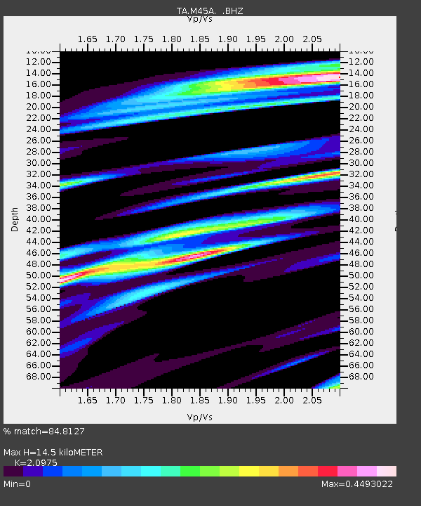
| Estimated Moho Depth: |
14.5 km |
| Estimated Crust Vp/Vs: |
2.10 |
| Assumed Crust Vp: |
6.498 km/s |
| Estimated Crust Vs: |
3.098 km/s |
| Estimated Crust Poisson's Ratio: |
0.35 |
|
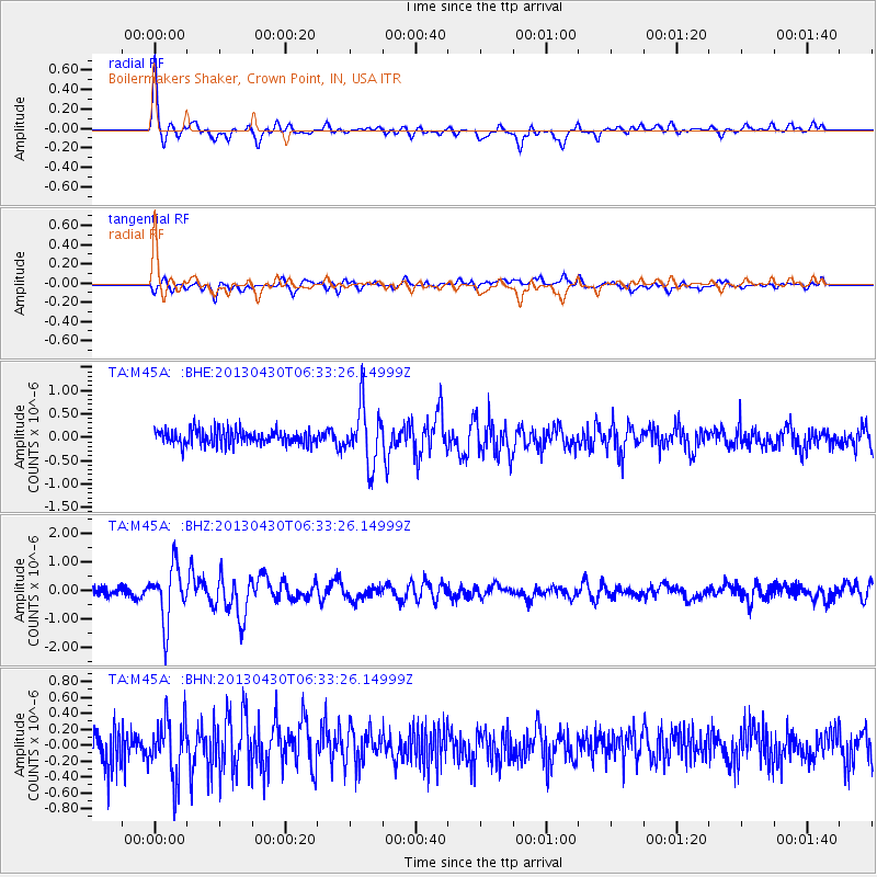
| Radial Match: |
84.8127 % |
| Radial Bump: |
364 |
| Transverse Match: |
67.431755 % |
| Transverse Bump: |
400 |
| SOD ConfigId: |
512894 |
| Insert Time: |
2013-09-13 21:06:30.051 +0000 |
| GWidth: |
2.5 |
| Max Bumps: |
400 |
| Tol: |
0.001 |
|
Signal To Noise
| Channel | StoN | STA | LTA |
| TA:M45A: :BHZ:20130430T06:33:26.14999Z | 7.0322223 | 9.713997E-7 | 1.3813552E-7 |
| TA:M45A: :BHN:20130430T06:33:26.14999Z | 2.010074 | 3.731294E-7 | 1.856297E-7 |
| TA:M45A: :BHE:20130430T06:33:26.14999Z | 3.8309903 | 6.118432E-7 | 1.5970889E-7 |
| Arrivals |
| Ps | 2.6 SECOND |
| PpPs | 6.6 SECOND |
| PsPs/PpSs | 9.1 SECOND |


