You are here: Home > Network List > TA - USArray Transportable Network (new EarthScope stations) Stations List
> Station M50A Fremont, OH, USA > Earthquake Result Viewer
M50A Fremont, OH, USA - Earthquake Result Viewer
| Earthquake location: |
Azores Islands Region |
| Earthquake latitude/longitude: |
37.6/-24.9 |
| Earthquake time(UTC): |
2013/04/30 (120) 06:25:23 GMT |
| Earthquake Depth: |
10 km |
| Earthquake Magnitude: |
5.8 MW, 5.9 MW, 5.9 MB |
| Earthquake Catalog/Contributor: |
NEIC PDE/NEIC PDE-W |
|
| Network: |
TA USArray Transportable Network (new EarthScope stations) |
| Station: |
M50A Fremont, OH, USA |
| Lat/Lon: |
41.40 N/83.04 W |
| Elevation: |
176 m |
|
| Distance: |
44.3 deg |
| Az: |
293.823 deg |
| Baz: |
75.009 deg |
| Ray Param: |
0.072003946 |
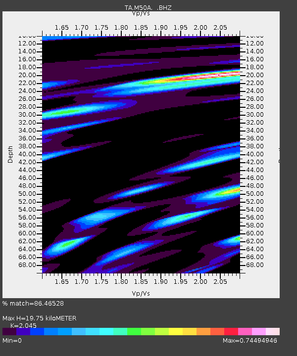
| Estimated Moho Depth: |
19.75 km |
| Estimated Crust Vp/Vs: |
2.05 |
| Assumed Crust Vp: |
6.498 km/s |
| Estimated Crust Vs: |
3.177 km/s |
| Estimated Crust Poisson's Ratio: |
0.34 |
|
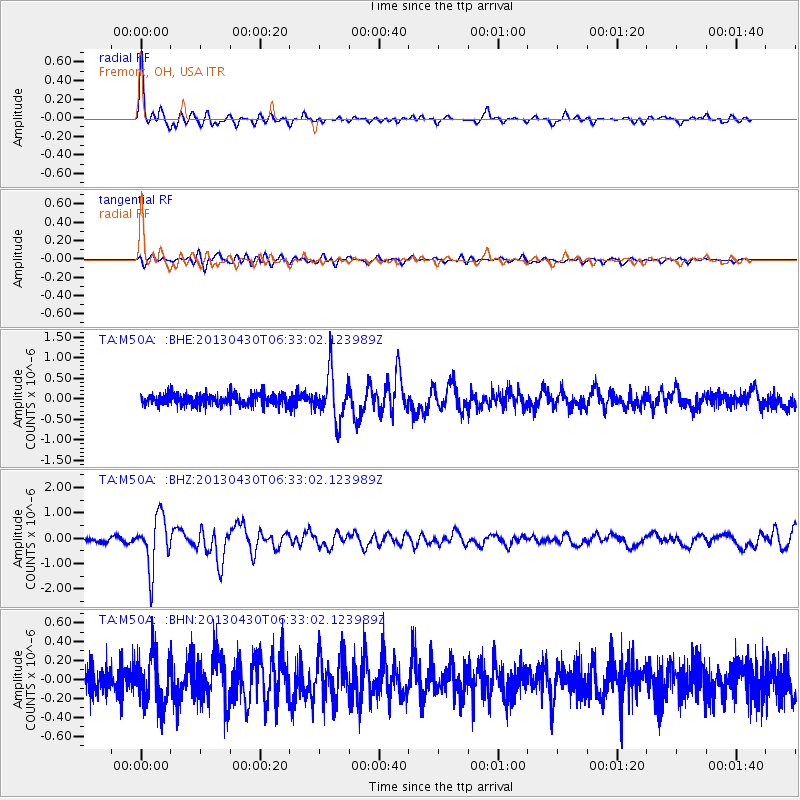
| Radial Match: |
86.46528 % |
| Radial Bump: |
360 |
| Transverse Match: |
75.13568 % |
| Transverse Bump: |
400 |
| SOD ConfigId: |
512894 |
| Insert Time: |
2013-09-13 21:06:52.178 +0000 |
| GWidth: |
2.5 |
| Max Bumps: |
400 |
| Tol: |
0.001 |
|
Signal To Noise
| Channel | StoN | STA | LTA |
| TA:M50A: :BHZ:20130430T06:33:02.123989Z | 9.842578 | 1.0171725E-6 | 1.03344114E-7 |
| TA:M50A: :BHN:20130430T06:33:02.123989Z | 1.7055575 | 2.7060977E-7 | 1.5866352E-7 |
| TA:M50A: :BHE:20130430T06:33:02.123989Z | 4.063412 | 5.5804554E-7 | 1.3733421E-7 |
| Arrivals |
| Ps | 3.4 SECOND |
| PpPs | 8.7 SECOND |
| PsPs/PpSs | 12 SECOND |


