You are here: Home > Network List > TA - USArray Transportable Network (new EarthScope stations) Stations List
> Station M52A Chesterland, OH, USA > Earthquake Result Viewer
M52A Chesterland, OH, USA - Earthquake Result Viewer
| Earthquake location: |
Azores Islands Region |
| Earthquake latitude/longitude: |
37.6/-24.9 |
| Earthquake time(UTC): |
2013/04/30 (120) 06:25:23 GMT |
| Earthquake Depth: |
10 km |
| Earthquake Magnitude: |
5.8 MW, 5.9 MW, 5.9 MB |
| Earthquake Catalog/Contributor: |
NEIC PDE/NEIC PDE-W |
|
| Network: |
TA USArray Transportable Network (new EarthScope stations) |
| Station: |
M52A Chesterland, OH, USA |
| Lat/Lon: |
41.54 N/81.36 W |
| Elevation: |
382 m |
|
| Distance: |
43.0 deg |
| Az: |
293.555 deg |
| Baz: |
75.927 deg |
| Ray Param: |
0.0728103 |
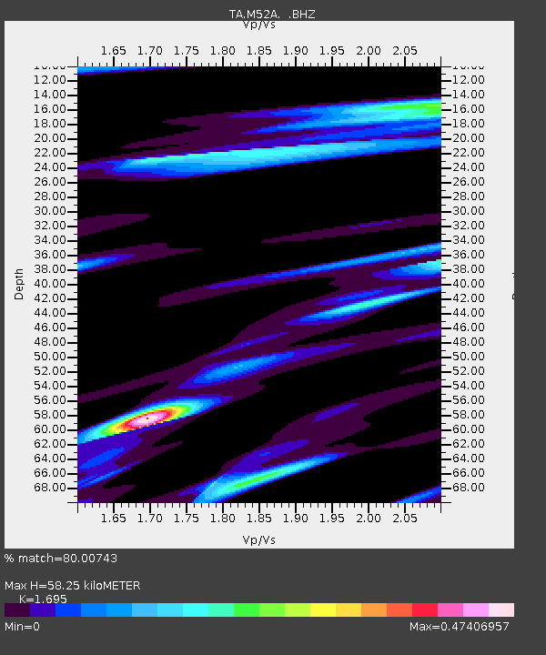
| Estimated Moho Depth: |
58.25 km |
| Estimated Crust Vp/Vs: |
1.70 |
| Assumed Crust Vp: |
6.483 km/s |
| Estimated Crust Vs: |
3.825 km/s |
| Estimated Crust Poisson's Ratio: |
0.23 |
|
| Radial Match: |
80.00743 % |
| Radial Bump: |
346 |
| Transverse Match: |
64.07293 % |
| Transverse Bump: |
369 |
| SOD ConfigId: |
512894 |
| Insert Time: |
2013-09-13 21:06:56.238 +0000 |
| GWidth: |
2.5 |
| Max Bumps: |
400 |
| Tol: |
0.001 |
|
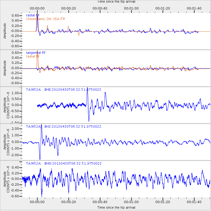
Signal To Noise
| Channel | StoN | STA | LTA |
| TA:M52A: :BHZ:20130430T06:32:51.975002Z | 9.368343 | 1.1353663E-6 | 1.2119179E-7 |
| TA:M52A: :BHN:20130430T06:32:51.975002Z | 1.8483908 | 2.0696952E-7 | 1.1197281E-7 |
| TA:M52A: :BHE:20130430T06:32:51.975002Z | 5.90342 | 6.184852E-7 | 1.0476727E-7 |
| Arrivals |
| Ps | 6.7 SECOND |
| PpPs | 23 SECOND |
| PsPs/PpSs | 29 SECOND |


