You are here: Home > Network List > TA - USArray Transportable Network (new EarthScope stations) Stations List
> Station N45A Kentland, IN, USA > Earthquake Result Viewer
N45A Kentland, IN, USA - Earthquake Result Viewer
| Earthquake location: |
Azores Islands Region |
| Earthquake latitude/longitude: |
37.6/-24.9 |
| Earthquake time(UTC): |
2013/04/30 (120) 06:25:23 GMT |
| Earthquake Depth: |
10 km |
| Earthquake Magnitude: |
5.8 MW, 5.9 MW, 5.9 MB |
| Earthquake Catalog/Contributor: |
NEIC PDE/NEIC PDE-W |
|
| Network: |
TA USArray Transportable Network (new EarthScope stations) |
| Station: |
N45A Kentland, IN, USA |
| Lat/Lon: |
40.85 N/87.51 W |
| Elevation: |
206 m |
|
| Distance: |
47.7 deg |
| Az: |
294.397 deg |
| Baz: |
72.479 deg |
| Ray Param: |
0.06982763 |
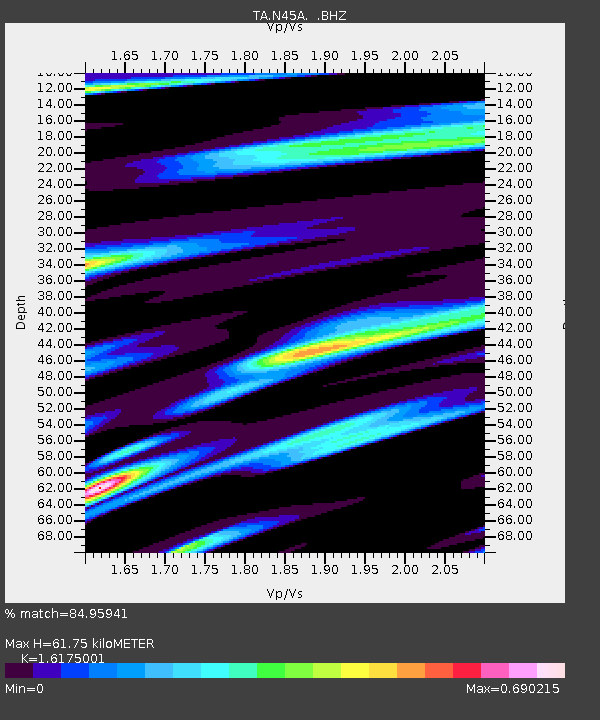
| Estimated Moho Depth: |
61.75 km |
| Estimated Crust Vp/Vs: |
1.62 |
| Assumed Crust Vp: |
6.498 km/s |
| Estimated Crust Vs: |
4.017 km/s |
| Estimated Crust Poisson's Ratio: |
0.19 |
|
| Radial Match: |
84.95941 % |
| Radial Bump: |
400 |
| Transverse Match: |
67.13893 % |
| Transverse Bump: |
400 |
| SOD ConfigId: |
512894 |
| Insert Time: |
2013-09-13 21:07:36.258 +0000 |
| GWidth: |
2.5 |
| Max Bumps: |
400 |
| Tol: |
0.001 |
|
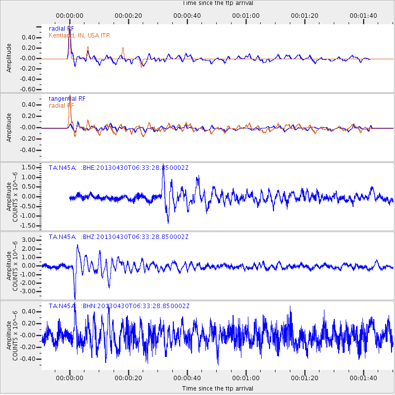
Signal To Noise
| Channel | StoN | STA | LTA |
| TA:N45A: :BHZ:20130430T06:33:28.850002Z | 11.069795 | 1.4096381E-6 | 1.2734094E-7 |
| TA:N45A: :BHN:20130430T06:33:28.850002Z | 1.2825674 | 1.8019296E-7 | 1.4049394E-7 |
| TA:N45A: :BHE:20130430T06:33:28.850002Z | 6.6939583 | 6.887258E-7 | 1.0288767E-7 |
| Arrivals |
| Ps | 6.3 SECOND |
| PpPs | 23 SECOND |
| PsPs/PpSs | 30 SECOND |


