You are here: Home > Network List > TA - USArray Transportable Network (new EarthScope stations) Stations List
> Station O43A Sugar Creek Farm, Atlanta, IL, USA > Earthquake Result Viewer
O43A Sugar Creek Farm, Atlanta, IL, USA - Earthquake Result Viewer
| Earthquake location: |
Azores Islands Region |
| Earthquake latitude/longitude: |
37.6/-24.9 |
| Earthquake time(UTC): |
2013/04/30 (120) 06:25:23 GMT |
| Earthquake Depth: |
10 km |
| Earthquake Magnitude: |
5.8 MW, 5.9 MW, 5.9 MB |
| Earthquake Catalog/Contributor: |
NEIC PDE/NEIC PDE-W |
|
| Network: |
TA USArray Transportable Network (new EarthScope stations) |
| Station: |
O43A Sugar Creek Farm, Atlanta, IL, USA |
| Lat/Lon: |
40.29 N/89.31 W |
| Elevation: |
224 m |
|
| Distance: |
49.2 deg |
| Az: |
294.255 deg |
| Baz: |
71.218 deg |
| Ray Param: |
0.06887199 |
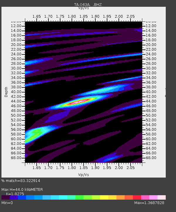
| Estimated Moho Depth: |
44.0 km |
| Estimated Crust Vp/Vs: |
1.83 |
| Assumed Crust Vp: |
6.498 km/s |
| Estimated Crust Vs: |
3.555 km/s |
| Estimated Crust Poisson's Ratio: |
0.29 |
|
| Radial Match: |
83.322914 % |
| Radial Bump: |
400 |
| Transverse Match: |
67.298195 % |
| Transverse Bump: |
400 |
| SOD ConfigId: |
512894 |
| Insert Time: |
2013-09-13 21:08:25.310 +0000 |
| GWidth: |
2.5 |
| Max Bumps: |
400 |
| Tol: |
0.001 |
|
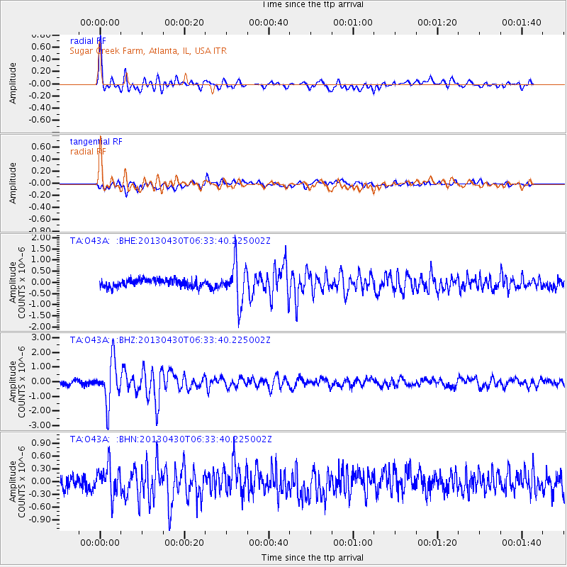
Signal To Noise
| Channel | StoN | STA | LTA |
| TA:O43A: :BHZ:20130430T06:33:40.225002Z | 10.890648 | 1.4716177E-6 | 1.3512674E-7 |
| TA:O43A: :BHN:20130430T06:33:40.225002Z | 2.2031317 | 3.5359528E-7 | 1.6049665E-7 |
| TA:O43A: :BHE:20130430T06:33:40.225002Z | 5.307011 | 9.1865854E-7 | 1.731028E-7 |
| Arrivals |
| Ps | 5.9 SECOND |
| PpPs | 18 SECOND |
| PsPs/PpSs | 24 SECOND |


