You are here: Home > Network List > TA - USArray Transportable Network (new EarthScope stations) Stations List
> Station O42A Bath, IL, USA > Earthquake Result Viewer
O42A Bath, IL, USA - Earthquake Result Viewer
| Earthquake location: |
Azores Islands Region |
| Earthquake latitude/longitude: |
37.6/-24.9 |
| Earthquake time(UTC): |
2013/04/30 (120) 06:25:23 GMT |
| Earthquake Depth: |
10 km |
| Earthquake Magnitude: |
5.8 MW, 5.9 MW, 5.9 MB |
| Earthquake Catalog/Contributor: |
NEIC PDE/NEIC PDE-W |
|
| Network: |
TA USArray Transportable Network (new EarthScope stations) |
| Station: |
O42A Bath, IL, USA |
| Lat/Lon: |
40.20 N/90.08 W |
| Elevation: |
155 m |
|
| Distance: |
49.8 deg |
| Az: |
294.394 deg |
| Baz: |
70.814 deg |
| Ray Param: |
0.06849806 |
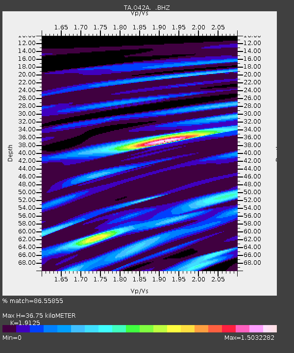
| Estimated Moho Depth: |
36.75 km |
| Estimated Crust Vp/Vs: |
1.91 |
| Assumed Crust Vp: |
6.498 km/s |
| Estimated Crust Vs: |
3.397 km/s |
| Estimated Crust Poisson's Ratio: |
0.31 |
|
| Radial Match: |
86.55855 % |
| Radial Bump: |
400 |
| Transverse Match: |
72.10541 % |
| Transverse Bump: |
400 |
| SOD ConfigId: |
512894 |
| Insert Time: |
2013-09-13 21:08:26.136 +0000 |
| GWidth: |
2.5 |
| Max Bumps: |
400 |
| Tol: |
0.001 |
|

Signal To Noise
| Channel | StoN | STA | LTA |
| TA:O42A: :BHZ:20130430T06:33:44.699001Z | 10.516801 | 1.5477503E-6 | 1.4716932E-7 |
| TA:O42A: :BHN:20130430T06:33:44.699001Z | 2.9952314 | 4.2330228E-7 | 1.413254E-7 |
| TA:O42A: :BHE:20130430T06:33:44.699001Z | 7.054524 | 1.0790591E-6 | 1.5295987E-7 |
| Arrivals |
| Ps | 5.5 SECOND |
| PpPs | 16 SECOND |
| PsPs/PpSs | 21 SECOND |


