You are here: Home > Network List > TA - USArray Transportable Network (new EarthScope stations) Stations List
> Station O50A Cable, OH, USA > Earthquake Result Viewer
O50A Cable, OH, USA - Earthquake Result Viewer

| Earthquake location: |
Azores Islands Region |
| Earthquake latitude/longitude: |
37.6/-24.9 |
| Earthquake time(UTC): |
2013/04/30 (120) 06:25:23 GMT |
| Earthquake Depth: |
10 km |
| Earthquake Magnitude: |
5.8 MW, 5.9 MW, 5.9 MB |
| Earthquake Catalog/Contributor: |
NEIC PDE/NEIC PDE-W |
|
| Network: |
TA USArray Transportable Network (new EarthScope stations) |
| Station: |
O50A Cable, OH, USA |
| Lat/Lon: |
40.15 N/83.62 W |
| Elevation: |
399 m |
|
| Distance: |
45.1 deg |
| Az: |
292.274 deg |
| Baz: |
73.532 deg |
| Ray Param: |
0.07152878 |
| Estimated Moho Depth: |
48.0 km |
| Estimated Crust Vp/Vs: |
1.70 |
| Assumed Crust Vp: |
6.498 km/s |
| Estimated Crust Vs: |
3.828 km/s |
| Estimated Crust Poisson's Ratio: |
0.23 |
|
| Radial Match: |
88.56089 % |
| Radial Bump: |
327 |
| Transverse Match: |
71.392815 % |
| Transverse Bump: |
400 |
| SOD ConfigId: |
512894 |
| Insert Time: |
2013-09-13 21:08:43.895 +0000 |
| GWidth: |
2.5 |
| Max Bumps: |
400 |
| Tol: |
0.001 |
|
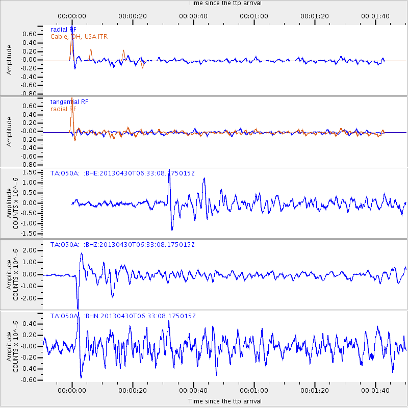
Signal To Noise
| Channel | StoN | STA | LTA |
| TA:O50A: :BHZ:20130430T06:33:08.175015Z | 13.28823 | 1.0755657E-6 | 8.094123E-8 |
| TA:O50A: :BHN:20130430T06:33:08.175015Z | 3.754432 | 2.831214E-7 | 7.540992E-8 |
| TA:O50A: :BHE:20130430T06:33:08.175015Z | 8.502324 | 6.578307E-7 | 7.737069E-8 |
| Arrivals |
| Ps | 5.5 SECOND |
| PpPs | 19 SECOND |
| PsPs/PpSs | 24 SECOND |


