You are here: Home > Network List > TA - USArray Transportable Network (new EarthScope stations) Stations List
> Station Q48A North Vernon, IN, USA > Earthquake Result Viewer
Q48A North Vernon, IN, USA - Earthquake Result Viewer
| Earthquake location: |
Azores Islands Region |
| Earthquake latitude/longitude: |
37.6/-24.9 |
| Earthquake time(UTC): |
2013/04/30 (120) 06:25:23 GMT |
| Earthquake Depth: |
10 km |
| Earthquake Magnitude: |
5.8 MW, 5.9 MW, 5.9 MB |
| Earthquake Catalog/Contributor: |
NEIC PDE/NEIC PDE-W |
|
| Network: |
TA USArray Transportable Network (new EarthScope stations) |
| Station: |
Q48A North Vernon, IN, USA |
| Lat/Lon: |
38.93 N/85.73 W |
| Elevation: |
185 m |
|
| Distance: |
47.0 deg |
| Az: |
291.343 deg |
| Baz: |
71.547 deg |
| Ray Param: |
0.070294656 |
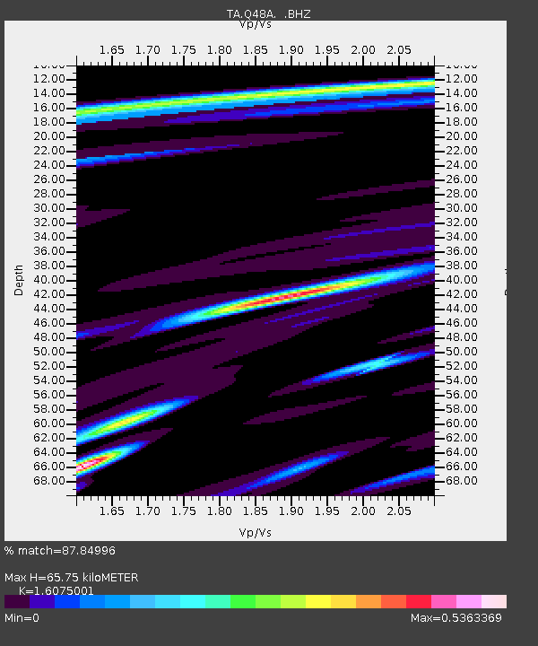
| Estimated Moho Depth: |
65.75 km |
| Estimated Crust Vp/Vs: |
1.61 |
| Assumed Crust Vp: |
6.498 km/s |
| Estimated Crust Vs: |
4.042 km/s |
| Estimated Crust Poisson's Ratio: |
0.18 |
|
| Radial Match: |
87.84996 % |
| Radial Bump: |
296 |
| Transverse Match: |
61.018932 % |
| Transverse Bump: |
380 |
| SOD ConfigId: |
512894 |
| Insert Time: |
2013-09-13 21:10:25.611 +0000 |
| GWidth: |
2.5 |
| Max Bumps: |
400 |
| Tol: |
0.001 |
|
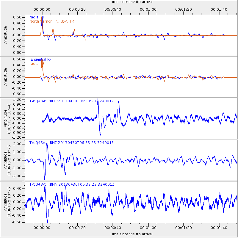
Signal To Noise
| Channel | StoN | STA | LTA |
| TA:Q48A: :BHZ:20130430T06:33:23.324001Z | 7.887107 | 1.1453786E-6 | 1.4522165E-7 |
| TA:Q48A: :BHN:20130430T06:33:23.324001Z | 3.3654037 | 2.8140758E-7 | 8.361778E-8 |
| TA:Q48A: :BHE:20130430T06:33:23.324001Z | 5.985233 | 5.675463E-7 | 9.482443E-8 |
| Arrivals |
| Ps | 6.6 SECOND |
| PpPs | 25 SECOND |
| PsPs/PpSs | 31 SECOND |


