You are here: Home > Network List > TA - USArray Transportable Network (new EarthScope stations) Stations List
> Station R47A Wooly Knot Farm, English, IN, USA > Earthquake Result Viewer
R47A Wooly Knot Farm, English, IN, USA - Earthquake Result Viewer
| Earthquake location: |
Azores Islands Region |
| Earthquake latitude/longitude: |
37.6/-24.9 |
| Earthquake time(UTC): |
2013/04/30 (120) 06:25:23 GMT |
| Earthquake Depth: |
10 km |
| Earthquake Magnitude: |
5.8 MW, 5.9 MW, 5.9 MB |
| Earthquake Catalog/Contributor: |
NEIC PDE/NEIC PDE-W |
|
| Network: |
TA USArray Transportable Network (new EarthScope stations) |
| Station: |
R47A Wooly Knot Farm, English, IN, USA |
| Lat/Lon: |
38.30 N/86.53 W |
| Elevation: |
181 m |
|
| Distance: |
47.8 deg |
| Az: |
290.803 deg |
| Baz: |
70.687 deg |
| Ray Param: |
0.06977596 |
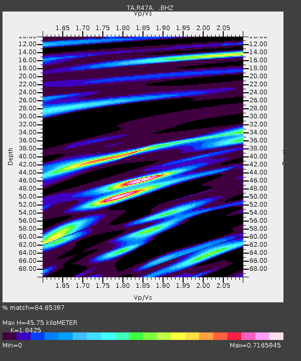
| Estimated Moho Depth: |
45.75 km |
| Estimated Crust Vp/Vs: |
1.84 |
| Assumed Crust Vp: |
6.444 km/s |
| Estimated Crust Vs: |
3.497 km/s |
| Estimated Crust Poisson's Ratio: |
0.29 |
|
| Radial Match: |
84.65397 % |
| Radial Bump: |
281 |
| Transverse Match: |
74.021614 % |
| Transverse Bump: |
400 |
| SOD ConfigId: |
512894 |
| Insert Time: |
2013-09-13 21:11:10.643 +0000 |
| GWidth: |
2.5 |
| Max Bumps: |
400 |
| Tol: |
0.001 |
|

Signal To Noise
| Channel | StoN | STA | LTA |
| TA:R47A: :BHZ:20130430T06:33:29.499996Z | 12.5333605 | 1.2858436E-6 | 1.0259369E-7 |
| TA:R47A: :BHN:20130430T06:33:29.499996Z | 4.074369 | 3.948264E-7 | 9.690493E-8 |
| TA:R47A: :BHE:20130430T06:33:29.499996Z | 5.802137 | 5.3586155E-7 | 9.235589E-8 |
| Arrivals |
| Ps | 6.3 SECOND |
| PpPs | 19 SECOND |
| PsPs/PpSs | 25 SECOND |


