You are here: Home > Network List > TA - USArray Transportable Network (new EarthScope stations) Stations List
> Station R49A Shelbyville, KY, USA > Earthquake Result Viewer
R49A Shelbyville, KY, USA - Earthquake Result Viewer
| Earthquake location: |
Azores Islands Region |
| Earthquake latitude/longitude: |
37.6/-24.9 |
| Earthquake time(UTC): |
2013/04/30 (120) 06:25:23 GMT |
| Earthquake Depth: |
10 km |
| Earthquake Magnitude: |
5.8 MW, 5.9 MW, 5.9 MB |
| Earthquake Catalog/Contributor: |
NEIC PDE/NEIC PDE-W |
|
| Network: |
TA USArray Transportable Network (new EarthScope stations) |
| Station: |
R49A Shelbyville, KY, USA |
| Lat/Lon: |
38.29 N/85.17 W |
| Elevation: |
251 m |
|
| Distance: |
46.8 deg |
| Az: |
290.324 deg |
| Baz: |
71.198 deg |
| Ray Param: |
0.07043595 |
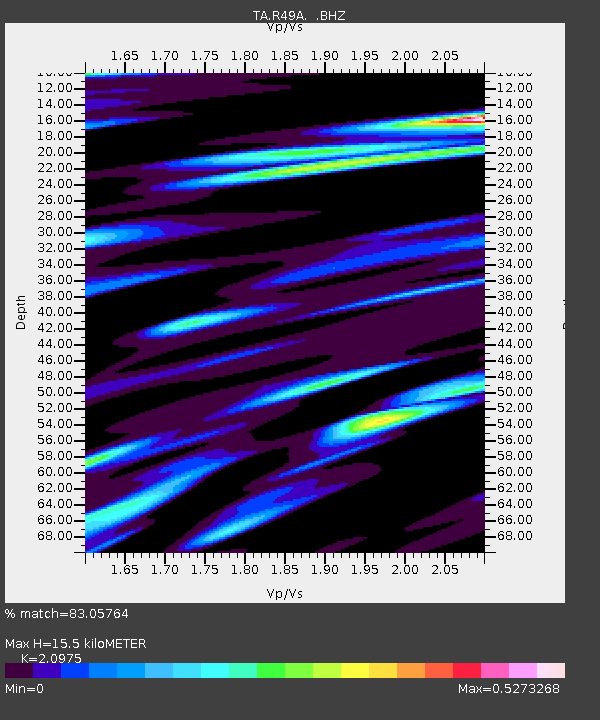
| Estimated Moho Depth: |
15.5 km |
| Estimated Crust Vp/Vs: |
2.10 |
| Assumed Crust Vp: |
6.498 km/s |
| Estimated Crust Vs: |
3.098 km/s |
| Estimated Crust Poisson's Ratio: |
0.35 |
|
| Radial Match: |
83.05764 % |
| Radial Bump: |
305 |
| Transverse Match: |
61.411926 % |
| Transverse Bump: |
361 |
| SOD ConfigId: |
512894 |
| Insert Time: |
2013-09-13 21:11:16.354 +0000 |
| GWidth: |
2.5 |
| Max Bumps: |
400 |
| Tol: |
0.001 |
|
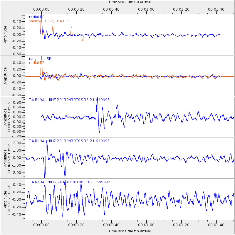
Signal To Noise
| Channel | StoN | STA | LTA |
| TA:R49A: :BHZ:20130430T06:33:21.64999Z | 9.790066 | 1.1521314E-6 | 1.17683726E-7 |
| TA:R49A: :BHN:20130430T06:33:21.64999Z | 1.9467556 | 2.0717493E-7 | 1.06420615E-7 |
| TA:R49A: :BHE:20130430T06:33:21.64999Z | 7.0162926 | 5.2931705E-7 | 7.544113E-8 |
| Arrivals |
| Ps | 2.8 SECOND |
| PpPs | 7.0 SECOND |
| PsPs/PpSs | 9.8 SECOND |


