You are here: Home > Network List > TA - USArray Transportable Network (new EarthScope stations) Stations List
> Station R51A Hillsboro, KY, USA > Earthquake Result Viewer
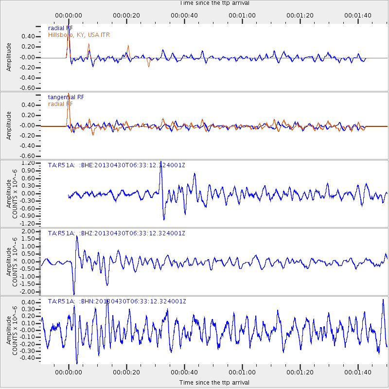
R51A Hillsboro, KY, USA - Earthquake Result Viewer
*The percent match for this event was below the threshold and hence no stack was calculated.
| Earthquake location: |
Azores Islands Region |
| Earthquake latitude/longitude: |
37.6/-24.9 |
| Earthquake time(UTC): |
2013/04/30 (120) 06:25:23 GMT |
| Earthquake Depth: |
10 km |
| Earthquake Magnitude: |
5.8 MW, 5.9 MW, 5.9 MB |
| Earthquake Catalog/Contributor: |
NEIC PDE/NEIC PDE-W |
|
| Network: |
TA USArray Transportable Network (new EarthScope stations) |
| Station: |
R51A Hillsboro, KY, USA |
| Lat/Lon: |
38.30 N/83.58 W |
| Elevation: |
231 m |
|
| Distance: |
45.6 deg |
| Az: |
289.786 deg |
| Baz: |
71.805 deg |
| Ray Param: |
$rayparam |
*The percent match for this event was below the threshold and hence was not used in the summary stack. |
|
| Radial Match: |
77.54445 % |
| Radial Bump: |
365 |
| Transverse Match: |
65.62732 % |
| Transverse Bump: |
377 |
| SOD ConfigId: |
512894 |
| Insert Time: |
2013-09-13 21:11:22.671 +0000 |
| GWidth: |
2.5 |
| Max Bumps: |
400 |
| Tol: |
0.001 |
|
Signal To Noise
| Channel | StoN | STA | LTA |
| TA:R51A: :BHZ:20130430T06:33:12.324001Z | 8.862533 | 8.907547E-7 | 1.0050791E-7 |
| TA:R51A: :BHN:20130430T06:33:12.324001Z | 2.4837034 | 2.1350968E-7 | 8.5964245E-8 |
| TA:R51A: :BHE:20130430T06:33:12.324001Z | 6.3846455 | 5.3578566E-7 | 8.391784E-8 |
| Arrivals |
| Ps | |
| PpPs | |
| PsPs/PpSs | |


