You are here: Home > Network List > TA - USArray Transportable Network (new EarthScope stations) Stations List
> Station R58B Mineral, VA, USA > Earthquake Result Viewer
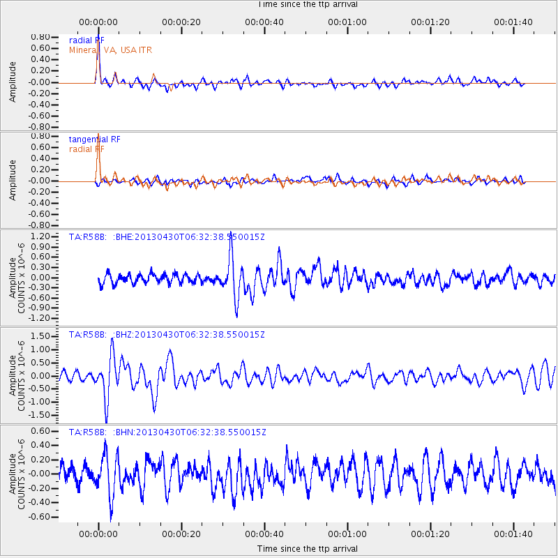
R58B Mineral, VA, USA - Earthquake Result Viewer
*The percent match for this event was below the threshold and hence no stack was calculated.
| Earthquake location: |
Azores Islands Region |
| Earthquake latitude/longitude: |
37.6/-24.9 |
| Earthquake time(UTC): |
2013/04/30 (120) 06:25:23 GMT |
| Earthquake Depth: |
10 km |
| Earthquake Magnitude: |
5.8 MW, 5.9 MW, 5.9 MB |
| Earthquake Catalog/Contributor: |
NEIC PDE/NEIC PDE-W |
|
| Network: |
TA USArray Transportable Network (new EarthScope stations) |
| Station: |
R58B Mineral, VA, USA |
| Lat/Lon: |
37.96 N/77.88 W |
| Elevation: |
116 m |
|
| Distance: |
41.4 deg |
| Az: |
287.375 deg |
| Baz: |
73.565 deg |
| Ray Param: |
$rayparam |
*The percent match for this event was below the threshold and hence was not used in the summary stack. |
|
| Radial Match: |
76.82332 % |
| Radial Bump: |
400 |
| Transverse Match: |
61.433163 % |
| Transverse Bump: |
400 |
| SOD ConfigId: |
512894 |
| Insert Time: |
2013-09-13 21:11:51.099 +0000 |
| GWidth: |
2.5 |
| Max Bumps: |
400 |
| Tol: |
0.001 |
|
Signal To Noise
| Channel | StoN | STA | LTA |
| TA:R58B: :BHZ:20130430T06:32:38.550015Z | 6.291362 | 8.01438E-7 | 1.2738704E-7 |
| TA:R58B: :BHN:20130430T06:32:38.550015Z | 2.1397073 | 2.9097149E-7 | 1.3598657E-7 |
| TA:R58B: :BHE:20130430T06:32:38.550015Z | 4.611406 | 6.048238E-7 | 1.3115822E-7 |
| Arrivals |
| Ps | |
| PpPs | |
| PsPs/PpSs | |


