You are here: Home > Network List > TA - USArray Transportable Network (new EarthScope stations) Stations List
> Station S45A Carrier Mills, IL, USA > Earthquake Result Viewer
S45A Carrier Mills, IL, USA - Earthquake Result Viewer
| Earthquake location: |
Azores Islands Region |
| Earthquake latitude/longitude: |
37.6/-24.9 |
| Earthquake time(UTC): |
2013/04/30 (120) 06:25:23 GMT |
| Earthquake Depth: |
10 km |
| Earthquake Magnitude: |
5.8 MW, 5.9 MW, 5.9 MB |
| Earthquake Catalog/Contributor: |
NEIC PDE/NEIC PDE-W |
|
| Network: |
TA USArray Transportable Network (new EarthScope stations) |
| Station: |
S45A Carrier Mills, IL, USA |
| Lat/Lon: |
37.68 N/88.58 W |
| Elevation: |
122 m |
|
| Distance: |
49.5 deg |
| Az: |
290.768 deg |
| Baz: |
69.405 deg |
| Ray Param: |
0.06865404 |
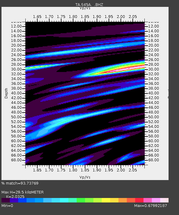
| Estimated Moho Depth: |
29.5 km |
| Estimated Crust Vp/Vs: |
2.03 |
| Assumed Crust Vp: |
6.444 km/s |
| Estimated Crust Vs: |
3.17 km/s |
| Estimated Crust Poisson's Ratio: |
0.34 |
|
| Radial Match: |
93.73769 % |
| Radial Bump: |
347 |
| Transverse Match: |
76.49522 % |
| Transverse Bump: |
400 |
| SOD ConfigId: |
512894 |
| Insert Time: |
2013-09-13 21:12:09.449 +0000 |
| GWidth: |
2.5 |
| Max Bumps: |
400 |
| Tol: |
0.001 |
|
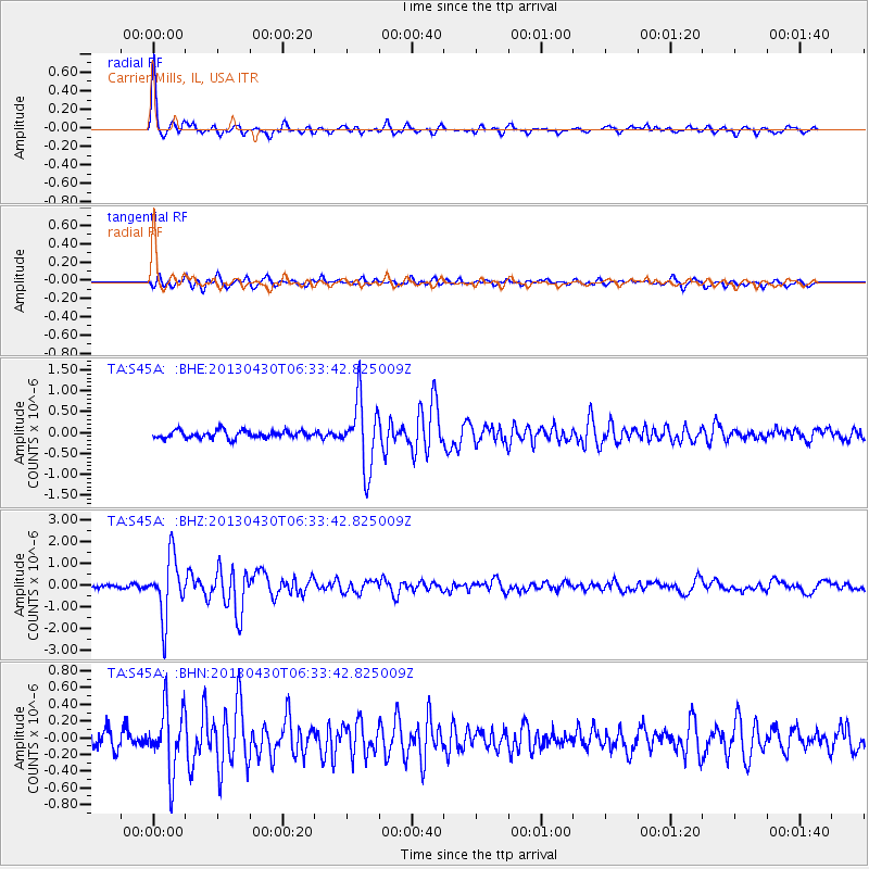
Signal To Noise
| Channel | StoN | STA | LTA |
| TA:S45A: :BHZ:20130430T06:33:42.825009Z | 19.079363 | 1.3645922E-6 | 7.15219E-8 |
| TA:S45A: :BHN:20130430T06:33:42.825009Z | 4.5696783 | 3.8031718E-7 | 8.322625E-8 |
| TA:S45A: :BHE:20130430T06:33:42.825009Z | 8.917563 | 8.0110226E-7 | 8.983421E-8 |
| Arrivals |
| Ps | 5.0 SECOND |
| PpPs | 13 SECOND |
| PsPs/PpSs | 18 SECOND |


