You are here: Home > Network List > TA - USArray Transportable Network (new EarthScope stations) Stations List
> Station S49A Springfield, KY, USA > Earthquake Result Viewer
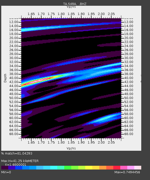
S49A Springfield, KY, USA - Earthquake Result Viewer
| Earthquake location: |
Azores Islands Region |
| Earthquake latitude/longitude: |
37.6/-24.9 |
| Earthquake time(UTC): |
2013/04/30 (120) 06:25:23 GMT |
| Earthquake Depth: |
10 km |
| Earthquake Magnitude: |
5.8 MW, 5.9 MW, 5.9 MB |
| Earthquake Catalog/Contributor: |
NEIC PDE/NEIC PDE-W |
|
| Network: |
TA USArray Transportable Network (new EarthScope stations) |
| Station: |
S49A Springfield, KY, USA |
| Lat/Lon: |
37.78 N/85.29 W |
| Elevation: |
230 m |
|
| Distance: |
47.0 deg |
| Az: |
289.71 deg |
| Baz: |
70.707 deg |
| Ray Param: |
0.07026823 |
| Estimated Moho Depth: |
41.25 km |
| Estimated Crust Vp/Vs: |
1.68 |
| Assumed Crust Vp: |
6.476 km/s |
| Estimated Crust Vs: |
3.855 km/s |
| Estimated Crust Poisson's Ratio: |
0.23 |
|
| Radial Match: |
81.04293 % |
| Radial Bump: |
314 |
| Transverse Match: |
67.28595 % |
| Transverse Bump: |
372 |
| SOD ConfigId: |
512894 |
| Insert Time: |
2013-09-13 21:12:22.459 +0000 |
| GWidth: |
2.5 |
| Max Bumps: |
400 |
| Tol: |
0.001 |
|

Signal To Noise
| Channel | StoN | STA | LTA |
| TA:S49A: :BHZ:20130430T06:33:23.624996Z | 8.58267 | 1.0745172E-6 | 1.2519614E-7 |
| TA:S49A: :BHN:20130430T06:33:23.624996Z | 1.6745834 | 1.4072741E-7 | 8.403726E-8 |
| TA:S49A: :BHE:20130430T06:33:23.624996Z | 5.340493 | 3.2400067E-7 | 6.0668675E-8 |
| Arrivals |
| Ps | 4.6 SECOND |
| PpPs | 16 SECOND |
| PsPs/PpSs | 21 SECOND |


