You are here: Home > Network List > TA - USArray Transportable Network (new EarthScope stations) Stations List
> Station S59A Mechanicsville, VA, USA > Earthquake Result Viewer
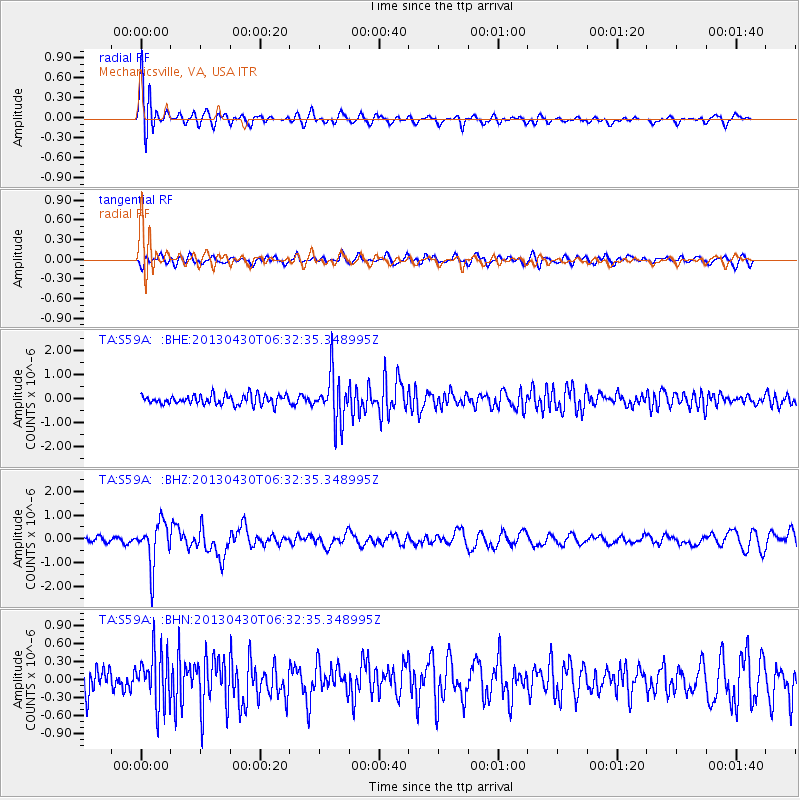
S59A Mechanicsville, VA, USA - Earthquake Result Viewer
*The percent match for this event was below the threshold and hence no stack was calculated.
| Earthquake location: |
Azores Islands Region |
| Earthquake latitude/longitude: |
37.6/-24.9 |
| Earthquake time(UTC): |
2013/04/30 (120) 06:25:23 GMT |
| Earthquake Depth: |
10 km |
| Earthquake Magnitude: |
5.8 MW, 5.9 MW, 5.9 MB |
| Earthquake Catalog/Contributor: |
NEIC PDE/NEIC PDE-W |
|
| Network: |
TA USArray Transportable Network (new EarthScope stations) |
| Station: |
S59A Mechanicsville, VA, USA |
| Lat/Lon: |
37.46 N/77.18 W |
| Elevation: |
40 m |
|
| Distance: |
41.0 deg |
| Az: |
286.398 deg |
| Baz: |
73.257 deg |
| Ray Param: |
$rayparam |
*The percent match for this event was below the threshold and hence was not used in the summary stack. |
|
| Radial Match: |
75.191895 % |
| Radial Bump: |
400 |
| Transverse Match: |
53.795197 % |
| Transverse Bump: |
400 |
| SOD ConfigId: |
512894 |
| Insert Time: |
2013-09-13 21:12:56.615 +0000 |
| GWidth: |
2.5 |
| Max Bumps: |
400 |
| Tol: |
0.001 |
|
Signal To Noise
| Channel | StoN | STA | LTA |
| TA:S59A: :BHZ:20130430T06:32:35.348995Z | 5.5107265 | 9.0626827E-7 | 1.6445532E-7 |
| TA:S59A: :BHN:20130430T06:32:35.348995Z | 2.4983342 | 4.558447E-7 | 1.8245946E-7 |
| TA:S59A: :BHE:20130430T06:32:35.348995Z | 5.060118 | 1.0019985E-6 | 1.9801878E-7 |
| Arrivals |
| Ps | |
| PpPs | |
| PsPs/PpSs | |


